IMAGES TAKEN NEAR TO
Jacksons Way, CROYDON, CR0 8EX
Introduction
This page details the photographs taken nearby to Jacksons Way, CR0 8EX by members of the Geograph project.
The Geograph project started in 2005 with the aim of publishing, organising and preserving representative images for every square kilometre of Great Britain, Ireland and the Isle of Man.

There are currently over 7.5m images from over14,400 individuals and you can help contribute to the project by visiting https://www.geograph.org.uk
Image Map
Images are licensed for reuse under creativecommons.org/licenses/by-sa/2.0
Notes
- Clicking on the map will re-center to the selected point.
- The higher the marker number, the further away the image location is from the centre of the postcode.
Image Listing (36 Images Found)
Images are licensed for reuse under creativecommons.org/licenses/by-sa/2.0
Image
Details
Distance
1
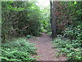
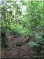
Footpath into the wood east of Oak Avenue, CR0
Image: © Mike Quinn
Taken: 16 Jun 2010
0.07 miles
2
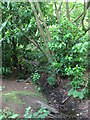
The Beck east of Oak Avenue, CR0
This is the furthest point south that I found water in the stream bed (June 2010).
Image: © Mike Quinn
Taken: 16 Jun 2010
0.09 miles
3
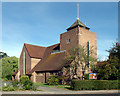
All Saints church, Spring Park, Shirley, Croydon
Built in 1955 - 56 (architects: Curtis Green, Son and Lloyd) this grade-2 listed church consists of the traditional nave, aisle, chancel, chapel on the south side of the chancel and vestries symmetrically placed to the north of the chancel. A tower and belfry rise above the chancel. Walls are load-bearing and reinforced concrete ‘gothic’ - shaped arches support the roof at the crossing with the transepts. The acoustics are terrible!
Image: © Philip Talmage
Taken: 4 Aug 2005
0.09 miles
4
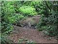
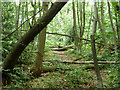
Footpath crossing The Beck in the wood east of Oak Avenue, CR0
Image: © Mike Quinn
Taken: 16 Jun 2010
0.09 miles
5
The course of The Beck east of Oak Avenue, CR0
There was water in the stream bed about 50 yards to the north - see Image
Image: © Mike Quinn
Taken: 16 Jun 2010
0.10 miles
6
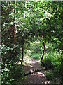
Footpath in the wood east of Bracken Avenue, CR0
Image: © Mike Quinn
Taken: 16 Jun 2010
0.12 miles
7

Spring Park Wood
This rather sad little rectangular patch of woodland is one of the remnants of what, even in the 1930s, was a very large wood - see the current and 1930s OS maps http://wtp2.appspot.com/wheresthepath.htm?lat=51.3725305044254&lon=-0.026092529296875&gz=14&oz=8>=5.
Image: © Mike Quinn
Taken: 16 Jun 2010
0.14 miles
9
The northern finger of Threehalfpenny Wood
This runs north for some way, but the paths are lightly used.
Image: © Robin Webster
Taken: 1 Jul 2011
0.15 miles
10
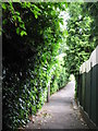
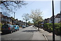
Alleyway between Links View Road, CR0 and Copse Avenue, BR4
The Beck passes under the path by the first tree on the right.
Image: © Mike Quinn
Taken: 16 Jun 2010
0.15 miles