IMAGES TAKEN NEAR TO
Northampton Road, CROYDON, CR0 7HD
Introduction
This page details the photographs taken nearby to Northampton Road, CR0 7HD by members of the Geograph project.
The Geograph project started in 2005 with the aim of publishing, organising and preserving representative images for every square kilometre of Great Britain, Ireland and the Isle of Man.

There are currently over 7.5m images from over14,400 individuals and you can help contribute to the project by visiting https://www.geograph.org.uk
Image Map
Images are licensed for reuse under creativecommons.org/licenses/by-sa/2.0
Notes
- Clicking on the map will re-center to the selected point.
- The higher the marker number, the further away the image location is from the centre of the postcode.
Image Listing (80 Images Found)
Images are licensed for reuse under creativecommons.org/licenses/by-sa/2.0
Image
Details
Distance
1
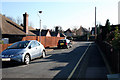
Croydon: Ashburton Close
Looking east into this very short cul de sac which is off the east side of Ashburton Road.
Image: © Dr Neil Clifton
Taken: 5 Mar 2010
0.04 miles
2
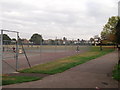
Addiscombe Recreational Ground
This large square open-space area is accessed from either Northampton Road or Fryston Avenue.
Image: © David Anstiss
Taken: 16 Oct 2011
0.08 miles
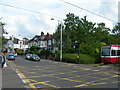
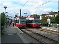
3
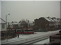
Tram and snow
Picture was taken on Mar 4 2005, in a very short snow frenzy. Tram is just pulling out of Addiscombe Tram stop (Bingham Road end)
Image: © June Shutt
Taken: 4 Mar 2005
0.08 miles
4
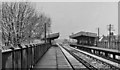
Bingham Road (Croydon) Station
View northward, towards Woodside; Woodside - Sanderstead loop line. Station built 30/9/35 when line electrified, closed 16/5/83; line replaced in part by Croydon Tramlink (opened 5/00) but here it runs at road level.
Image: © Ben Brooksbank
Taken: 2 Apr 1968
0.08 miles
5
Tram Crossing, Bingham Road, Addiscombe
Image: © Danny P Robinson
Taken: 21 Jun 2007
0.09 miles
6
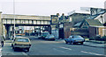
Bingham Road station, Addiscombe, 1983
View westward on Addiscombe Road: ex-SE&CR Woodside - Sanderstead line, closed 15/5/83; Woodside and London are to the right, Sanderstead to the left.
Image: © Ben Brooksbank
Taken: 2 Jan 1983
0.10 miles
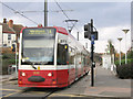
7
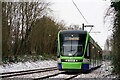
Tramlink
Tram approaching the Addiscombe tram stop.
Image: © Peter Trimming
Taken: 8 Feb 2021
0.10 miles
8
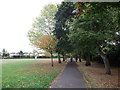
Path in Addiscombe Recreational Ground
This large square open-space area is accessed from either Northampton Road or Fryston Avenue.
A path leads around the outskirts of the ground. This section under trees.
Image: © David Anstiss
Taken: 16 Oct 2011
0.11 miles
9
Addiscombe Tram Stop
I am standing at the Bingham Road end.
Image: © Danny P Robinson
Taken: 21 Jun 2007
0.11 miles
10
Tram at Addiscombe
One of the original Tramlink units on route 1 to Wimbledon.
Image: © Stephen Craven
Taken: 11 Feb 2006
0.13 miles