1
Croydon: Outram Road
Looking north from its T-junction with Addiscombe Road. At the far end of this straight road it ends at another T-junction with Lower Addiscombe Road.
Image: © Dr Neil Clifton
Taken: 5 Mar 2010
0.02 miles
2
No.20 Outram Road, Addiscombe
House with a blue plaque.
Image: © David Anstiss
Taken: 16 Oct 2011
0.02 miles
3
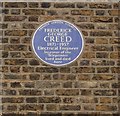
Frederick George Creed's Blue Plaque
On
Image
See http://en.wikipedia.org/wiki/Frederick_G._Creed for more details about the telecommunications inventor.
Image: © David Anstiss
Taken: 16 Oct 2011
0.02 miles
4
Croydon: Ashburton Gardens
Looking west along this very short cul de sac off the west side of Ashburton Road.
Image: © Dr Neil Clifton
Taken: 5 Mar 2010
0.03 miles
5
Croydon: Sandilands bus stop, eastbound
A Metrobus on Route 466, bound for Addington Village, calls at the Sandilands stop. This route starts from Caterham-on-the-Hill, Westway Common.
Image: © Dr Neil Clifton
Taken: 13 Sep 2006
0.05 miles
6
Croydon: South London Jamatkhana
Three large houses have been used to form this building: part of these was formerly used as a private school. The Jamatkhana is, as I understand it, a centre for the study of Ismaili, which is a sect of Islam led by the Aga Khan. It is on Addiscombe Road, should you wish to visit it, just opposite the Sandilands tram stop.
Image: © Dr Neil Clifton
Taken: 24 Feb 2010
0.06 miles
7
Croydon: Havelock Road
Looking north from the T-junction with Addiscombe Road. This road runs straight northwards to another T-junction with Lower Addiscombe Road.
Image: © Dr Neil Clifton
Taken: 5 Mar 2010
0.06 miles
8
Havelock Road, Croydon
Looking north.
Image: © Robin Webster
Taken: 19 Apr 2019
0.06 miles
9
Outram Rd
Image: © N Chadwick
Taken: 9 Apr 2011
0.06 miles
10
Looking west from Sandilands tramstop, Croydon
The Tramlink stop at Sandilands is where the branch from New Addington meets the line from Beckenham and Elmers End, both occupying part of the former railway line that terminated at Selsdon. The picture shows new line, towards Croydon. A tram is approaching, and the "threepenny bit building", as it is known locally (actually the NLA Tower) is in the background.
Image: © Philip Talmage
Taken: 2 Aug 2005
0.07 miles


