IMAGES TAKEN NEAR TO
Cedar Road, CROYDON, CR0 6UB
Introduction
This page details the photographs taken nearby to Cedar Road, CR0 6UB by members of the Geograph project.
The Geograph project started in 2005 with the aim of publishing, organising and preserving representative images for every square kilometre of Great Britain, Ireland and the Isle of Man.

There are currently over 7.5m images from over14,400 individuals and you can help contribute to the project by visiting https://www.geograph.org.uk
Image Map
Images are licensed for reuse under creativecommons.org/licenses/by-sa/2.0
Notes
- Clicking on the map will re-center to the selected point.
- The higher the marker number, the further away the image location is from the centre of the postcode.
Image Listing (566 Images Found)
Images are licensed for reuse under creativecommons.org/licenses/by-sa/2.0
Image
Details
Distance
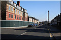
1
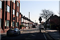
Croydon: Cedar Road
Seen from its T-junction with Cherry Orchard Road, Cedar Road cannot be exited at this end. The road runs to a junction with Lebanon Road at the far end.
Image: © Dr Neil Clifton
Taken: 8 Apr 2010
0.01 miles
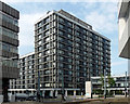
2
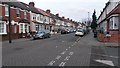
Cedar Road at junction with Blake Road
Image: © David Martin
Taken: 18 Jan 2016
0.03 miles
3
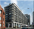
Commercial Union House, Cherry Orchard Road
One of Croydon's best new office blocks in Pevsner's opinion, crisply detailed and well proportioned. By the Austin-Smith/Lord Partnership, 1965-68. The projecting frame is clad in white mosaic, recessed behind which are black mosaic verticals. It has now been split into two blocks, this section being known as Stephenson House (the other section is the far taller slab Image]).
Between the 1950s and the 1970s Croydon experienced a burst of commercial development unparalleled anywhere else in the country. The impetus was provided by the Croydon Corporation Act of 1956 which gave Croydon Council powers to develop land in the borough. A combination of improved roads, government incentives to relocate from, and Croydon's proximity to, central London, and lower rents attracted employers in their droves. By 1970 about six million square feet of office space had been provided in central Croydon. Development has continued since, but at a much slower rate. From a distance the skyline is impressive (the nearest this country comes to Manhattan), but the problem is that few of the buildings are of architectural merit.
Image: © Stephen Richards
Taken: 31 Jul 2011
0.06 miles
4
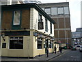
Porter & Sorter Public House, East Croydon
Tucked away on the eastern side of East Croydon station, this pub has been much re-built, and extended, since I played darts here in the late 1970's.
Behind the pub is East Croydon Post Office sorting office. In the days of Mail trains, mailbags were conveyed across the bridge (to the right of photograph) into the sorting office.
Image: © Peter Trimming
Taken: 15 Apr 2009
0.07 miles
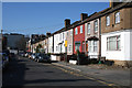
5
Croydon: Oval Road
Looking east from the junction with Cherry Orchard Road. The nearest block on the left is empty and closed, hopefully for refurbishment.
Image: © Dr Neil Clifton
Taken: 5 Mar 2010
0.07 miles
6
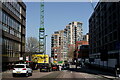
Croydon
Cherry Orchard Road, with construction of further tower blocks under way.
Image: © Peter Trimming
Taken: 4 Apr 2021
0.07 miles
7
Croydon: Oval Road
Looking west towards its T-junction with Cherry Orchard Road. The houses are numbered up to 83, odds. At the far end, the high-rise buildings of central Croydon can be seen.
Image: © Dr Neil Clifton
Taken: 5 Mar 2010
0.07 miles
8
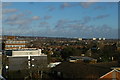
Crystal Palace hill from Croydon
Dominating the skyline, the Crystal Palace hill, which rises to a little under 400 feet. On its summit, two transmitter masts: that on the left, the former ITV mast, is located next to All Saints Upper Norwood, whilst the BBC mast to the right is in Crystal Palace Park. Between them, to the right of the white flagpole and a little below the skyline, one can just make out the Holmesdale Road stand at Selhurst Park, the home of Crystal Palace FC. Below the right mast and about halfway towards the photographer, a lightly wooded area marks the former Croydon Common, now the location of the complicated railway junctions between Selhurst, Norwood Junction and the two Croydon stations. Moving to the right again, breaking the horizon one sees the white floodlight supports of the National Sports Centre in Crystal Palace Park. Finally, at the bottom of the hill's slope, the towers of Canary Wharf, which at 800+ feet are over twice the height of the hill and can thus be seen for many miles around; here they are probably some 15 miles off.
Image: © Christopher Hilton
Taken: 1 Feb 2014
0.07 miles
9

Croydon: Station Road (East Croydon)
Not to be confused with the better-known Station Road at West Croydon, this short road off Cherry Orchard Road must be entered by taxis to access the taxi stance and also cars intending to drop off or collect passengers, when a very short wait only is allowed.
Image: © Dr Neil Clifton
Taken: 8 Apr 2010
0.08 miles
10
Commercial Union House, Addiscombe Road
One of Croydon's best new office blocks in Pevsner's opinion, crisply detailed and well proportioned. By the Austin-Smith/Lord Partnership, 1965-68. The projecting frame is clad in white mosaic, recessed behind which are black mosaic verticals. It has now been split into two blocks, this section being known as Knolly's House (the other section runs behind Image]).
Between the 1950s and the 1970s Croydon experienced a burst of commercial development unparalleled anywhere else in the country. The impetus was provided by the Croydon Corporation Act of 1956 which gave Croydon Council powers to develop land in the borough. A combination of improved roads, government incentives to relocate from, and Croydon's proximity to, central London, and lower rents attracted employers in their droves. By 1970 about six million square feet of office space had been provided in central Croydon. Development has continued since, but at a much slower rate. From a distance the skyline is impressive (the nearest this country comes to Manhattan), but the problem is that few of the buildings are of architectural merit.
Top right is a sliver of this beauty: Image
Image: © Stephen Richards
Taken: 31 Jul 2011
0.08 miles