IMAGES TAKEN NEAR TO
Stretton Road, CROYDON, CR0 6ES
Introduction
This page details the photographs taken nearby to Stretton Road, CR0 6ES by members of the Geograph project.
The Geograph project started in 2005 with the aim of publishing, organising and preserving representative images for every square kilometre of Great Britain, Ireland and the Isle of Man.

There are currently over 7.5m images from over14,400 individuals and you can help contribute to the project by visiting https://www.geograph.org.uk
Image Map
Images are licensed for reuse under creativecommons.org/licenses/by-sa/2.0
Notes
- Clicking on the map will re-center to the selected point.
- The higher the marker number, the further away the image location is from the centre of the postcode.
Image Listing (49 Images Found)
Images are licensed for reuse under creativecommons.org/licenses/by-sa/2.0
Image
Details
Distance
1

Croydon: Stretton Road
Looking southeast. From a T-junction with Davidson Road, Stretton Road crosses three other roads before ending at another T-junction with Morland Road.
Image: © Dr Neil Clifton
Taken: 14 Jun 2010
0.09 miles
2

The Leslie Arms and Cherry Orchard Road, Croydon CR0
Looking southwest from Addiscombe Road. Despite being closed and shuttered, the Leslie Arms is a grade 2 listed building.
Image: © Philip Talmage
Taken: 8 Sep 2005
0.13 miles
3

Lower Addiscombe Road, Croydon CR0
Shops being reconverted to dwellings, just east of the railway.
Image: © Philip Talmage
Taken: 8 Sep 2005
0.13 miles
4

Davidson Road
Housing on Davidson Road, these ones first marked on the 1913 25" map when this section of the road was named Albert Road.
Image: © Ian Capper
Taken: 6 Jul 2024
0.13 miles
5

Stretton Road, Croydon
Stretton Road is a residential road in Croydon, in the outer suburbs of south London.
Image: © Malc McDonald
Taken: 4 Mar 2023
0.13 miles
6
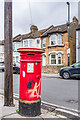
Anonymous postbox, Davidson Road
An "anonymous" postbox on Davidson Road by its junction with Stretton Road - see Image for a wider view. The lack of royal cipher, hence the description "anonymous", is a particular feature of boxes dated between 1879 and 1887 manufactured by the firm Handyside during this period. The positioning of the aperture implies that this box dates from before 1883, later ones having the aperture positioned lower down.
Note the "Banksy"-style stencilled rat on the front - I assume it's not genuine!
Image: © Ian Capper
Taken: 6 Jul 2024
0.13 miles
7

Davidson Road
Housing on Davidson Road, with some first marked on the 1897 25" map, others on the 1913 edition. On both editions this section of the road was named Albert Road.
Image: © Ian Capper
Taken: 6 Jul 2024
0.14 miles
8
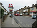
Bus stop on Davidson Road, Croydon
A bus stop on Davidson Road, a residential road in Croydon in the outer suburbs of south London. The bus stop carries the "roundel" sign of Transport for London (TfL), as the stop is within Greater London and served by a TfL bus route.
The bus stop flag includes a notice reminding bus drivers to check the road ahead. With parked cars both sides, there is little room for two buses to pass.
Image: © Malc McDonald
Taken: 4 Mar 2023
0.14 miles
9
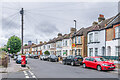
Davidson Road
Housing on Davidson Road, with the nearest ones first marked on the 1897 25" map when this section of the road was named Albert Road. Note the "anonymous" postbox on the left - see Image for a close up.
Image: © Ian Capper
Taken: 6 Jul 2024
0.14 miles
