IMAGES TAKEN NEAR TO
Oval Road, CROYDON, CR0 6BG
Introduction
This page details the photographs taken nearby to Oval Road, CR0 6BG by members of the Geograph project.
The Geograph project started in 2005 with the aim of publishing, organising and preserving representative images for every square kilometre of Great Britain, Ireland and the Isle of Man.

There are currently over 7.5m images from over14,400 individuals and you can help contribute to the project by visiting https://www.geograph.org.uk
Image Map
Images are licensed for reuse under creativecommons.org/licenses/by-sa/2.0
Notes
- Clicking on the map will re-center to the selected point.
- The higher the marker number, the further away the image location is from the centre of the postcode.
Image Listing (296 Images Found)
Images are licensed for reuse under creativecommons.org/licenses/by-sa/2.0
Image
Details
Distance
1
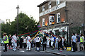
Croydon Night of Dance 2016
15 dance teams, 100+ dancers, three different locations ... and the locals looked on.
Image]
Image: © Peter Trimming
Taken: 16 Aug 2016
0.02 miles
2
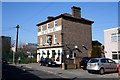
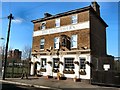
Croydon: The 'Oval Tavern', Oval Road
This pub is in some ways a remarkable (though very welcome) survival. Tucked away in a location which probably less than 2 per cent of Croydonians would know, it stands four-square and still serving good beer.
Image: © Dr Neil Clifton
Taken: 5 Mar 2010
0.03 miles
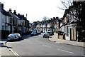
3
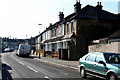
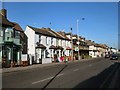
Croydon: Houses 169 to 161, Oval Road
Oval Road is a road of strange shape and idiosyncratic house numbering. These houses are near the junction of Oval Road with Leslie Park Road.
Image: © Dr Neil Clifton
Taken: 5 Mar 2010
0.03 miles
4
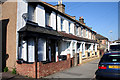
Croydon: Houses 161 to 169, Oval Road
Image: © Dr Neil Clifton
Taken: 5 Mar 2010
0.03 miles
5

Croydon Night of Dance 2016
15 dance teams, 100+ dancers, three different locations ... and the locals looked on.
Image]
Image: © Peter Trimming
Taken: 16 Aug 2016
0.04 miles
6
The Oval Tavern
In Oval Road, East of East Croydon station
Image: © Paul Gillett
Taken: 25 Feb 2012
0.04 miles
7
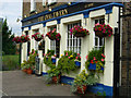
Oval Tavern, Croydon
This pub takes its name from Oval Road, a small estate of Victorian houses, although the pub building pre-dates them.
Image: © Stephen McKay
Taken: 27 Jun 2007
0.05 miles
8
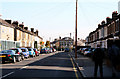
Croydon: Oval Road and Oval House
Looking east. Oval House is the building facing the camera. It is the largest house on Oval Road, and it situated precisely where the two arms of Oval Road divide, only to re-unite end-on thus forming a symmetrical oval shape, off which there is a short link to Leslie Park Road.
Image: © Dr Neil Clifton
Taken: 5 Mar 2010
0.06 miles
9
Cherry Orchard Road
North East of East Croydon Station
Image: © Paul Gillett
Taken: 25 Feb 2012
0.07 miles
10
Croydon: Lebanon Road
Taken from its northern end at a T-junction with Leslie Park Road. Lebanon Road runs north to another T-junction with Addiscombe Road.
Image: © Dr Neil Clifton
Taken: 5 Mar 2010
0.08 miles