IMAGES TAKEN NEAR TO
Crispin Crescent, CROYDON, CR0 4UE
Introduction
This page details the photographs taken nearby to Crispin Crescent, CR0 4UE by members of the Geograph project.
The Geograph project started in 2005 with the aim of publishing, organising and preserving representative images for every square kilometre of Great Britain, Ireland and the Isle of Man.

There are currently over 7.5m images from over14,400 individuals and you can help contribute to the project by visiting https://www.geograph.org.uk
Image Map
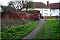
Images are licensed for reuse under creativecommons.org/licenses/by-sa/2.0
Notes
- Clicking on the map will re-center to the selected point.
- The higher the marker number, the further away the image location is from the centre of the postcode.
Image Listing (97 Images Found)
Images are licensed for reuse under creativecommons.org/licenses/by-sa/2.0
Image
Details
Distance
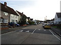
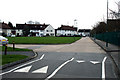
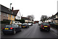
2
Beddington: Crispin Crescent, northern part
Looking east.
Image: © Dr Neil Clifton
Taken: 5 Apr 2010
0.03 miles
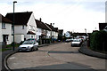
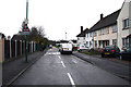
3
Beddington: Mallinson Road
Looking northeast the houses on the north side of Mallinson Road are set back to allow a wide green area. On the other side of Mallinson Road is a primary school.
Image: © Dr Neil Clifton
Taken: 5 Apr 2010
0.05 miles
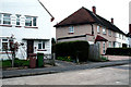
4
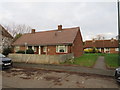
Crispin Close, Beddington
Crispin Close is a small development of bungalows in Beddington, in the outer suburbs of south London.
Image: © Malc McDonald
Taken: 4 Jan 2020
0.07 miles
5
Beddington: Mallinson Road
Looking east to where Mallinson Road meets the eastern leg of Crispin Crescent.
Image: © Dr Neil Clifton
Taken: 5 Apr 2010
0.08 miles
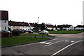
6
Beddington: Mallinson Road
Looking west from the start of the road. At the other end, the only outlet is to return to your starting point via Crispin Crescent.
Image: © Dr Neil Clifton
Taken: 31 Mar 2010
0.09 miles
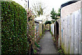
7
Beddington: The Wandle Trail
If walking the Wandle Trail you will arrive on the western leg of Crispin Crescent, where you must look out for the gap shown here between the hedge and the wooden fence. This leads to the passage through to re-join the river.
Image: © Dr Neil Clifton
Taken: 5 Apr 2010
0.10 miles
8
Beddington: The Wandle Trail
Looking west, this shows the passage which leads out of Crispin Crescent to re-join the river.
Image: © Dr Neil Clifton
Taken: 5 Apr 2010
0.10 miles
9
Beddington: The Wandle Trail
This shows the gap where the footpath enters Mallinson Road
Image: © Dr Neil Clifton
Taken: 5 Apr 2010
0.10 miles
10
Beddington: Crispin Crescent
This is looking north along the eastern leg of this horseshoe-shaped road, which starts where the photographer is standing at an end-on junction with Meller Close.
Image: © Dr Neil Clifton
Taken: 31 Mar 2010
0.10 miles