IMAGES TAKEN NEAR TO
The Waldrons, CROYDON, CR0 4AX
Introduction
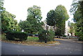
This page details the photographs taken nearby to The Waldrons, CR0 4AX by members of the Geograph project.
The Geograph project started in 2005 with the aim of publishing, organising and preserving representative images for every square kilometre of Great Britain, Ireland and the Isle of Man.

There are currently over 7.5m images from over14,400 individuals and you can help contribute to the project by visiting https://www.geograph.org.uk
Image Map
Images are licensed for reuse under creativecommons.org/licenses/by-sa/2.0
Notes
- Clicking on the map will re-center to the selected point.
- The higher the marker number, the further away the image location is from the centre of the postcode.
Image Listing (98 Images Found)
Images are licensed for reuse under creativecommons.org/licenses/by-sa/2.0
Image
Details
Distance

10
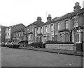
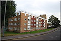
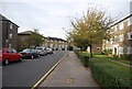
Tanfield Road, Croydon, Surrey - South side
The south side of Tanfield Road shows a mixture of housing types: probably Edwardian period terrace houses and semis - clearly built before the motor car had become popular - and at the far end, a block infilled with what are obviously post-WW2 apartments.
Image: © Dr Neil Clifton
Taken: 14 Oct 1979
0.11 miles