IMAGES TAKEN NEAR TO
Marden Crescent, CROYDON, CR0 3ES
Introduction
This page details the photographs taken nearby to Marden Crescent, CR0 3ES by members of the Geograph project.
The Geograph project started in 2005 with the aim of publishing, organising and preserving representative images for every square kilometre of Great Britain, Ireland and the Isle of Man.

There are currently over 7.5m images from over14,400 individuals and you can help contribute to the project by visiting https://www.geograph.org.uk
Image Map
Images are licensed for reuse under creativecommons.org/licenses/by-sa/2.0
Notes
- Clicking on the map will re-center to the selected point.
- The higher the marker number, the further away the image location is from the centre of the postcode.
Image Listing (36 Images Found)
Images are licensed for reuse under creativecommons.org/licenses/by-sa/2.0
Image
Details
Distance
1
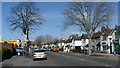
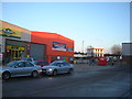
Street Scene in Thornton Road
Now part of the A23, this is generally a very busy road.
Image: © Peter Trimming
Taken: 24 Mar 2009
0.08 miles
2
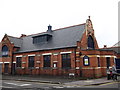
Boston Road Baptist Church, Broad Green
On the junction of Worsley Road (on the left) and Boston Road (on the right).
Image: © David Anstiss
Taken: 30 Oct 2011
0.12 miles
3

Flower beds at the entrance to Croydon Cemetery
Croydon Cemetery was opened in 1876. These flower beds are near the entrance to the Thornton Heath Extension in Thornton Road (A23).
Image: © Marathon
Taken: 11 Jul 2012
0.16 miles
4
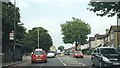
Thornton Road, heading towards Thornton Heath Pond
Thornton Road forms the north end of the A23's route around Croydon town centre, the route created in the 1920s by the building of Purley Way, and carries heavy traffic as a result.
Image: © Christopher Hilton
Taken: 23 Jul 2013
0.16 miles
5
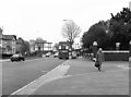
Thornton Road, Croydon
This road formed the northern section of the Purley Way bypass. This photograph was taken outside the gates of Croydon Crematorium. In the distance can be seen the cooling towers of Croydon power station. These were demolished several years ago.
Image: © Dr Neil Clifton
Taken: 21 Apr 1981
0.16 miles
6
Thornton Road Industrial Estate, Croydon
An industrial estate seemingly given over almost in its entirety to carpet warehouses and sales of other floor coverings.
Image: © Christopher Hilton
Taken: 15 Feb 2014
0.16 miles
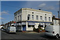
7
Golden Lion, Public house, Broad Green
Pub on the junction of Worley Road (on the left) and Stanley Road (on the right).
Has been re-painted since Image
Image: © David Anstiss
Taken: 30 Oct 2011
0.18 miles
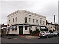
8
The Golden Lion Public House
Amazingly, I found a pub in this area which is still open!
Image: © Peter Trimming
Taken: 24 Mar 2009
0.18 miles
9
Mitcham Road Cemetery
Lanfranc Air Crash Memorial.
9th August 1961.
Thirty four pupils and two teachers of Lanfranc Secondary Modern School, Croydon, were killed when the Viking airliner they were flying in crashed while making the approach to the Sola Airport near Stavanger, Norway; they had been travelling to a camping holiday. The mass grave contains thirty four of the victims, buried together in Croydon Cemetery.
Image: © Peter Trimming
Taken: 12 Apr 2020
0.18 miles
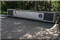
10
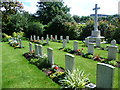
War graves and memorial in Croydon Cemetery
Croydon Cemetery was opened in 1876. It contains 195 scattered war graves of the First World War, most of them of local men. Some of the 150 Second World War burials form a small war graves plot in the Thornton Heath Extension. This is seen here together with the war memorial. As is so common elsewhere, they are beautifully kept in the manner of the war cemeteries in France and Belgium. Close by is the Archbishop Lanfranc School memorial to the Stavanger Air Crash of 1961 - see http://www.geograph.org.uk/photo/3033847
Image: © Marathon
Taken: 11 Jul 2012
0.18 miles