IMAGES TAKEN NEAR TO
Windmill Grove, CROYDON, CR0 2UQ
Introduction
This page details the photographs taken nearby to Windmill Grove, CR0 2UQ by members of the Geograph project.
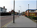
The Geograph project started in 2005 with the aim of publishing, organising and preserving representative images for every square kilometre of Great Britain, Ireland and the Isle of Man.

There are currently over 7.5m images from over14,400 individuals and you can help contribute to the project by visiting https://www.geograph.org.uk
Image Map
Images are licensed for reuse under creativecommons.org/licenses/by-sa/2.0
Notes
- Clicking on the map will re-center to the selected point.
- The higher the marker number, the further away the image location is from the centre of the postcode.
Image Listing (141 Images Found)
Images are licensed for reuse under creativecommons.org/licenses/by-sa/2.0
Image
Details
Distance
1
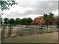
Play area off Windmill Grove, Croydon
Image: © Alex McGregor
Taken: 17 Jun 2011
0.04 miles
2
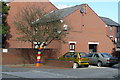
Rainbow Tree, Croydon
I've not seen one of these before, but it seems to be flourishing in its location, at the end of Prestwood Gardens.
Image: © Peter Trimming
Taken: 12 Oct 2009
0.05 miles
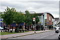
3
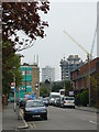
Queen's Road, Croydon
The flats and houses on either side of the road were built c1976, replacing the Victorian terraced houses which lined both sides of the road.
For a year I worked shifts. I remember walking along this road, one winter's night at about 11.30, on the way to start my nightshift. Damp air caused mist to form in the cemetery, which poured over the hedges and into the road. Then came the long terraces of boarded-up houses awaiting demolition. Not a soul was in sight ..... all very eerie.
In the middle distance in this photograph is the residential block being built at Spurgeon's Bridge, and in the distance is the tower block beside East Croydon station.
Image: © Peter Trimming
Taken: 20 Apr 2009
0.09 miles
4
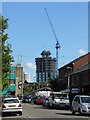
Queen's Road, Croydon
A break in the heavy traffic on this busy road. In the distance, the new housing development is taking shape.
Image: © Peter Trimming
Taken: 13 Jul 2009
0.09 miles
5
Croydon: Windmill Road
Seen from the busy six-way intersection still known as the 'Glos'ter', even though the eponymous pub was demolished several years ago.
Image: © Dr Neil Clifton
Taken: 28 Mar 2011
0.09 miles
6

Windmill Road, Croydon
Looking past the 'Fisherman's Arms', in the direction of the 'Gloucester' (pub; now demolished and replaced by Tesco, which gave its name to a five way road junction).
Windmill Road was named after the windmill, which stood near the Broad Green end of the road. Windmill Road was an ancient drove road; one of three which crossed Croydon Common. All three are now 'A' roads, and housing was built from c1870 onwards.
Image: © Peter Trimming
Taken: 7 Nov 2010
0.09 miles
7
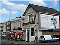
Fisherman's Arms, Windmill Road, Croydon
An afternoon scene on what appears to be a quiet road. Actually, it's quite the opposite, and I was surprised to get a clear shot at the pub between cars and buses.
Image: © Peter Trimming
Taken: 13 Jul 2009
0.10 miles
8
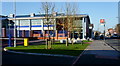
Metropolitan Police Custody Centre, Windmill Road, Croydon
Recently finished, and now awaiting its first customers, this custody centre, with 40 cells, will replace the custody facilities at both Croydon and South Norwood police stations, which had a combined 31 cells. Community Police Officers will also be based in this facility.
Image: © Peter Trimming
Taken: 27 Mar 2012
0.11 miles
9
Windmill Road
Following the fatal shooting of an officer (Sgt Matiu Ratana), at the Metropolitan Police Custody Unit, in Windmill Road, media descended on the location.
Image: © Peter Trimming
Taken: 25 Sep 2020
0.11 miles
10
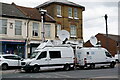
Windmill Road
Following the fatal shooting of an officer (Sgt Matiu Ratana), at the Metropolitan Police Custody Unit, in Windmill Road, media descended on the location. BBC and ITN outside broadcast vans.
Image: © Peter Trimming
Taken: 25 Sep 2020
0.11 miles