IMAGES TAKEN NEAR TO
Amersham Road, CROYDON, CR0 2QJ
Introduction
This page details the photographs taken nearby to Amersham Road, CR0 2QJ by members of the Geograph project.
The Geograph project started in 2005 with the aim of publishing, organising and preserving representative images for every square kilometre of Great Britain, Ireland and the Isle of Man.

There are currently over 7.5m images from over14,400 individuals and you can help contribute to the project by visiting https://www.geograph.org.uk
Image Map (74 Images)


Getting Data...Please wait
Leaflet Map data © OpenStreetMap
Images are licensed for reuse under creativecommons.org/licenses/by-sa/2.0
Notes
- Clicking on the map will re-center to the selected point.
- The higher the marker number, the further away the image location is from the centre of the postcode.
Image Listing (74 Images Found)
Images are licensed for reuse under creativecommons.org/licenses/by-sa/2.0
Image
Details
Distance
1
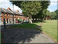
Whitehorse Road Recreation Ground
Whitehorse Road Recreation Ground was acquired by Croydon Council in 1891 as an informal play area for local children. An enclosed rest garden was built for elderly people to use and also a shelter. A fire was provided for them in the winter months. During the Second World War the main part of the field was used for ARP Shelters.
Image: © Marathon
Taken: 15 Sep 2022
0.04 miles
2

Whitehorse Road Recreation Ground
Whitehorse Road Recreation Ground was acquired by Croydon Council in 1891 as an informal play area for local children. An enclosed rest garden was built for elderly people to use and also a shelter. A fire was provided for them in the winter months. During the Second World War, the main part of the field was used for ARP Shelters.
Image: © Marathon
Taken: 11 Jul 2012
0.06 miles
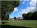
3

Whitehorse Road Recreation Ground
Whitehorse Road Recreation Ground was acquired by Croydon Council in 1891 as an informal play area for local children. An enclosed rest garden was built for elderly people to use and also a shelter. A fire was provided for them in the winter months. During the Second World War the main part of the field was used for ARP Shelters.
Image: © Marathon
Taken: 11 Jul 2012
0.06 miles
4
Whitehorse Road Recreation Ground
Whitehorse Road Recreation Ground was acquired by Croydon Council in 1891 as an informal play area for local children. An enclosed rest garden was built for elderly people to use and also a shelter. A fire was provided for them in the winter months. During the Second World War the main part of the field was used for ARP Shelters.
Image: © Marathon
Taken: 15 Sep 2022
0.06 miles
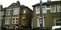
5
Northall Cottages, Whitehorse Road, Croydon
Image: © Christopher Hilton
Taken: 12 Dec 2015
0.07 miles
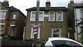
6
Northall Cottages and Clewer Terrace, Whitehorse Road, Croydon
Image: © Christopher Hilton
Taken: 12 Dec 2015
0.07 miles
7
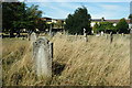
Queen's Road Cemetery, Croydon
In parts of the cemetery, grass is left to grow in order to provide a suitable environment for wildlife.
Image: © Peter Trimming
Taken: 8 Sep 2009
0.10 miles
9
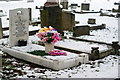
Queen's Road Cemetery, Croydon, in Winter (6)
White marble, white snow, colourful flowers.
Image: © Peter Trimming
Taken: 11 Jan 2010
0.12 miles
10
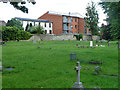
Houses and flats on Mayo Road
A rear view from Queen's Road Cemetery.
Image: © Robin Webster
Taken: 29 Jun 2011
0.12 miles