IMAGES TAKEN NEAR TO
Tait Road, CROYDON, CR0 2DP
Introduction
This page details the photographs taken nearby to Tait Road, CR0 2DP by members of the Geograph project.
The Geograph project started in 2005 with the aim of publishing, organising and preserving representative images for every square kilometre of Great Britain, Ireland and the Isle of Man.

There are currently over 7.5m images from over14,400 individuals and you can help contribute to the project by visiting https://www.geograph.org.uk
Image Map
Images are licensed for reuse under creativecommons.org/licenses/by-sa/2.0
Notes
- Clicking on the map will re-center to the selected point.
- The higher the marker number, the further away the image location is from the centre of the postcode.
Image Listing (74 Images Found)
Images are licensed for reuse under creativecommons.org/licenses/by-sa/2.0
Image
Details
Distance
4
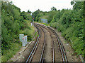
The West Croydon Line veers left
Up to this point, the line runs along the bed of the former Croydon Canal. In earlier times it continued to do so, running straight on, but remodelling of the complicated series of flyovers and junctions ahead led to a realignment.
Image: © Robin Webster
Taken: 29 Jun 2011
0.06 miles
5
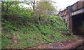
Railway cutting by Gloucester Road Bridge
Image: © N Chadwick
Taken: 8 May 2010
0.06 miles
6
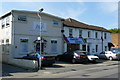
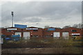
Light Industry in Gloucester Road
There is a wide variety of light industry on either side of Gloucester Road. In the centre of the picture is Roberts Cycles, who make top quality hand-made cycles. I have owned several of their cycles over the years.
http://www.robertscycles.com/
Image: © Peter Trimming
Taken: 24 Apr 2009
0.07 miles
7
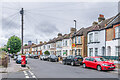
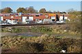
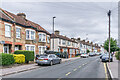
Davidson Road
Housing on Davidson Road, with the nearest ones first marked on the 1897 25" map when this section of the road was named Albert Road. Note the "anonymous" postbox on the left - see Image for a close up.
Image: © Ian Capper
Taken: 6 Jul 2024
0.08 miles
8
Davidson Road
Housing on Davidson Road, with some first marked on the 1897 25" map, others on the 1913 edition. On both editions this section of the road was named Albert Road.
Image: © Ian Capper
Taken: 6 Jul 2024
0.08 miles
9
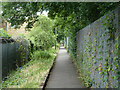
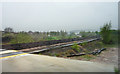
Path parallel to railway
This follows the railway as far as St. James's Road. As the railway was laid on the bed of the Croydon Canal, it has been suggested this was once the towpath.
Image: © Robin Webster
Taken: 29 Jun 2011
0.08 miles
10
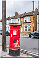
Anonymous postbox, Davidson Road
An "anonymous" postbox on Davidson Road by its junction with Stretton Road - see Image for a wider view. The lack of royal cipher, hence the description "anonymous", is a particular feature of boxes dated between 1879 and 1887 manufactured by the firm Handyside during this period. The positioning of the aperture implies that this box dates from before 1883, later ones having the aperture positioned lower down.
Note the "Banksy"-style stencilled rat on the front - I assume it's not genuine!
Image: © Ian Capper
Taken: 6 Jul 2024
0.09 miles