IMAGES TAKEN NEAR TO
Deanfield Gardens, Hurst Road, CROYDON, CR0 1JU
Introduction
This page details the photographs taken nearby to Deanfield Gardens, Hurst Road, CR0 1JU by members of the Geograph project.
The Geograph project started in 2005 with the aim of publishing, organising and preserving representative images for every square kilometre of Great Britain, Ireland and the Isle of Man.

There are currently over 7.5m images from over14,400 individuals and you can help contribute to the project by visiting https://www.geograph.org.uk
Image Map
Images are licensed for reuse under creativecommons.org/licenses/by-sa/2.0
Notes
- Clicking on the map will re-center to the selected point.
- The higher the marker number, the further away the image location is from the centre of the postcode.
Image Listing (147 Images Found)
Images are licensed for reuse under creativecommons.org/licenses/by-sa/2.0
Image
Details
Distance
1
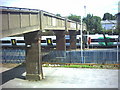
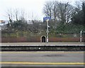
Footbridge over railway north of South Croydon Station.
Image: © Noel Foster
Taken: 4 Aug 2005
0.02 miles
2
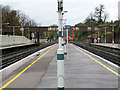
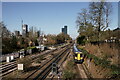
Railway footbridge at South Croydon
A view along the platform of South Croydon station showing a footbridge that is seen in close-up in the "first geograph" for the square Image
Image: © Stephen Craven
Taken: 11 Nov 2010
0.04 miles
4
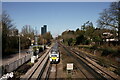
Croydon
View from the footbridge immediately north of South Croydon station.
Image: © Peter Trimming
Taken: 9 Mar 2021
0.05 miles
5
View Towards Croydon
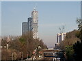
Tower blocks near East Croydon station. The block nearing completion stands at fifty storeys.
Image: © Peter Trimming
Taken: 16 Dec 2022
0.05 miles
6
Croydon
View from the footbridge immediately north of South Croydon station.
Image: © Peter Trimming
Taken: 9 Mar 2021
0.06 miles
7
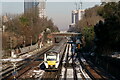
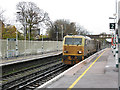
Rail Strike
Trains running on yet another rail strike day, with trains seen between East Croydon and South Croydon. It was estimated that 20% of services were running.
Image: © Peter Trimming
Taken: 16 Dec 2022
0.06 miles
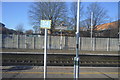
8
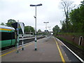
South Croydon station
South Croydon station was originally a terminus, next to the Brighton Line but without any platforms on it. It was at the end of a one-mile extension of the local lines from London to New Croydon station, opened by the London Brighton & South Coast Railway in 1865. The aim was to provide more space for reversing local trains than could be afforded at the busy New Croydon station. In 1894 the railway obtained authority to extend the local line from South Croydon to Coulsdon, parallel to the existing main line. The station was rebuilt as a through station with platforms on all the lines prior to the opening of the new line in November 1899. This photograph looks northwards along the down slow line on the right. On the left a train for Milton Keynes via the West London Line waits to start its journey. The Milton Keynes trains now terminate at South Croydon rather than East Croydon as there is more room for them to wait.
Image: © Marathon
Taken: 9 May 2012
0.06 miles
10
Network Rail vehicle at South Croydon
DR98963 is what is described as a "multi purpose vehicle" (MPV) that can carry various forms of railway maintenance plant. Its most common duty seems to be railhead cleaning, mainly an autumn task as fallen leaves make the rails slippery.
Image: © Stephen Craven
Taken: 11 Nov 2010
0.06 miles