IMAGES TAKEN NEAR TO
Dunley Drive, CROYDON, CR0 0RW
Introduction
This page details the photographs taken nearby to Dunley Drive, CR0 0RW by members of the Geograph project.
The Geograph project started in 2005 with the aim of publishing, organising and preserving representative images for every square kilometre of Great Britain, Ireland and the Isle of Man.

There are currently over 7.5m images from over14,400 individuals and you can help contribute to the project by visiting https://www.geograph.org.uk
Image Map
Images are licensed for reuse under creativecommons.org/licenses/by-sa/2.0
Notes
- Clicking on the map will re-center to the selected point.
- The higher the marker number, the further away the image location is from the centre of the postcode.
Image Listing (5 Images Found)
Images are licensed for reuse under creativecommons.org/licenses/by-sa/2.0
Image
Details
Distance

3

Building in allotments compound, New Addington
An unusual feature of allotments.
Image: © Robin Webster
Taken: 27 Feb 2011
0.23 miles
4
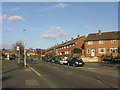
Headley Drive
This part of New Addington has all its roads named after Surrey villages and physical features. For example, as well as Headley Drive itself, the road off to the right is Netley Close, off to the left by the phone box is Witley Crescent, and the housing in the distance is variously on Merrow Way, Claygate Crescent and Milford Green.
Image: © Ian Capper
Taken: 1 Apr 2008
0.24 miles