IMAGES TAKEN NEAR TO
Cudham Drive, CROYDON, CR0 0LT
Introduction
This page details the photographs taken nearby to Cudham Drive, CR0 0LT by members of the Geograph project.
The Geograph project started in 2005 with the aim of publishing, organising and preserving representative images for every square kilometre of Great Britain, Ireland and the Isle of Man.

There are currently over 7.5m images from over14,400 individuals and you can help contribute to the project by visiting https://www.geograph.org.uk
Image Map
Images are licensed for reuse under creativecommons.org/licenses/by-sa/2.0
Notes
- Clicking on the map will re-center to the selected point.
- The higher the marker number, the further away the image location is from the centre of the postcode.
Image Listing (61 Images Found)
Images are licensed for reuse under creativecommons.org/licenses/by-sa/2.0
Image
Details
Distance
1
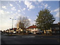
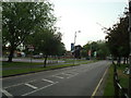
Homestead Way at the junction of Overbury Crescent
Image: © David Howard
Taken: 20 Apr 2014
0.04 miles
2
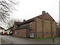
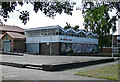
St Edward's church hall
The present hall on Cleves Crescent was built in 1992 to replace an earlier facility.
Image: © Stephen Craven
Taken: 29 Jan 2013
0.13 miles
4
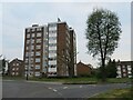
Block of flats in New Addington
A block of flats in New Addington, on the outskirts of south London.
Image: © Malc McDonald
Taken: 2 May 2022
0.14 miles
5
New Addington Leisure Centre
Swimming pool and gym, off Central Parade. http://www.fusion-lifestyle.com/centres/New_Addington_Leisure_Centre
Image: © Mike Faherty
Taken: 19 Mar 2016
0.14 miles

7
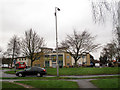
Library, New Addington
Opposite the shops on Central Parade. Built in 1964. New Addington was originally developed in the 1930s before being enlarged by Croydon Corporation as a quasi-new town. Pevsner describes it as a "classic example in the 1950s of prairie planning, or the pointless over-provision of open space, so that everything is too far apart." He describes the library as an effort to improve on amenities and "visual interest" (the zig-zag roof). A more recent extension is on the left.
Image: © Stephen Richards
Taken: Unknown
0.14 miles

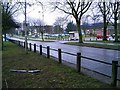
10
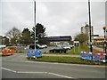
Roundabout at the end of Central Parade
Central Parade is a long axial road on the planned New Addington estate. This roundabout is at its eastern end, with St Edward's church Image facing it. The building at the far side of the roundabout in this view is the CALAT centre Image
The bus in the photo is on route T32, a shuttle service between Addington Village and New Addington.
Image: © Stephen Craven
Taken: 29 Jan 2013
0.16 miles