IMAGES TAKEN NEAR TO
Brabiner Gardens, CROYDON, CR0 0HT
Introduction
This page details the photographs taken nearby to Brabiner Gardens, CR0 0HT by members of the Geograph project.
The Geograph project started in 2005 with the aim of publishing, organising and preserving representative images for every square kilometre of Great Britain, Ireland and the Isle of Man.

There are currently over 7.5m images from over14,400 individuals and you can help contribute to the project by visiting https://www.geograph.org.uk
Image Map
Images are licensed for reuse under creativecommons.org/licenses/by-sa/2.0
Notes
- Clicking on the map will re-center to the selected point.
- The higher the marker number, the further away the image location is from the centre of the postcode.
Image Listing (56 Images Found)
Images are licensed for reuse under creativecommons.org/licenses/by-sa/2.0
Image
Details
Distance
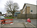
1
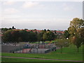
Queen's Elizabeth Drive open-space
This recreational ground is between Queen's Elizabeth Drive and Hares Bank.
In the far background is central London, and the tower blocks.
Image: © David Anstiss
Taken: 9 Oct 2011
0.06 miles
4
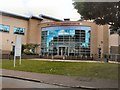
CALAT New Addington Centre
CALAT stands for Croydon Adult Learning and Training Centre http://www.calat.ac.uk/about-us/welcome-to-calat/
Image: © Paul Gillett
Taken: 12 Jul 2012
0.08 miles
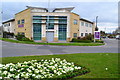
5
New Addington, One Stop Centre
Croydon Council library and one stop centre, off Central Parade.
Image: © Mike Faherty
Taken: 19 Mar 2016
0.08 miles
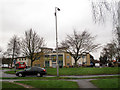
6
The New Addington Centre
Combined library and local council services.
Image: © David Martin
Taken: 3 Apr 2015
0.09 miles
7
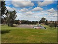
Roundabout at the end of Central Parade
Central Parade is a long axial road on the planned New Addington estate. This roundabout is at its eastern end, with St Edward's church Image facing it. The building at the far side of the roundabout in this view is the CALAT centre Image
The bus in the photo is on route T32, a shuttle service between Addington Village and New Addington.
Image: © Stephen Craven
Taken: 29 Jan 2013
0.09 miles
8
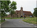
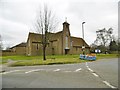
St. Edward's Church, New Addington
St. Edward's Church in New Addington, on the outskirts of south London.
Image: © Malc McDonald
Taken: 2 May 2022
0.10 miles
9
New Addington, St. Edward's
Parish church at the corner of Central Parade and Arnhem Drive. http://social.stedwardnewaddington.org.uk/wp/
Image: © Mike Faherty
Taken: 19 Mar 2016
0.10 miles
10
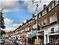
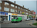
Central Parade, New Addington
New Addington's main street decorated in bunting in preparation for the Olympics
Image: © Paul Gillett
Taken: 12 Jul 2012
0.10 miles