IMAGES TAKEN NEAR TO
King Henrys Drive, CROYDON, CR0 0AE
Introduction
This page details the photographs taken nearby to King Henrys Drive, CR0 0AE by members of the Geograph project.
The Geograph project started in 2005 with the aim of publishing, organising and preserving representative images for every square kilometre of Great Britain, Ireland and the Isle of Man.

There are currently over 7.5m images from over14,400 individuals and you can help contribute to the project by visiting https://www.geograph.org.uk
Image Map
Images are licensed for reuse under creativecommons.org/licenses/by-sa/2.0
Notes
- Clicking on the map will re-center to the selected point.
- The higher the marker number, the further away the image location is from the centre of the postcode.
Image Listing (40 Images Found)
Images are licensed for reuse under creativecommons.org/licenses/by-sa/2.0
Image
Details
Distance
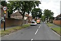
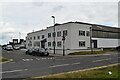
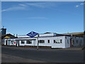
2
Boarded-up industrial building, New Addington
A "detached industrial unit with offices and yard" according to the agent's sign, extending to 2285 square metres.
Image: © Robin Webster
Taken: 27 Feb 2011
0.03 miles
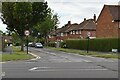
3
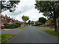
New Addington: Warbank Crescent
Shows the northern arm of Warbank Crescent, from its junction with King Henry's Drive.
Image: © Dr Neil Clifton
Taken: 1 Jun 2012
0.03 miles
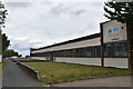
7
King Henry's Drive, New Addington
This industrial estate is on the eastern edge of New Addington. This view looks along King Henry's Drive which loops round this part of New Addington from the south-eastern edge to Lodge Lane and Parkway. Vulcan Way is the road leading off on the right, appropriate for a tyre centre.
Image: © Marathon
Taken: 30 Oct 2013
0.07 miles
8
King Henry's Drive, New Addington
This view looks along King Henry's Drive which loops round this part of New Addington from the south-eastern edge to Lodge Lane and Parkway. The blue railings on the left belong to Rowdown Primary School.
Image: © Marathon
Taken: 30 Oct 2013
0.10 miles
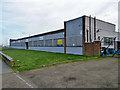
9
Angell Welding
A fabrication business on King Henry's Drive, New Addington.
Image: © Stephen Craven
Taken: 24 Jul 2011
0.10 miles
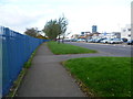
10
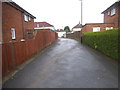
Path from King Henry's Drive and Warbank Crescent
Image: © David Howard
Taken: 20 Apr 2014
0.11 miles