IMAGES TAKEN NEAR TO
Jaggards Road, COLCHESTER, CO6 1PN
Introduction
This page details the photographs taken nearby to Jaggards Road, CO6 1PN by members of the Geograph project.
The Geograph project started in 2005 with the aim of publishing, organising and preserving representative images for every square kilometre of Great Britain, Ireland and the Isle of Man.

There are currently over 7.5m images from over14,400 individuals and you can help contribute to the project by visiting https://www.geograph.org.uk
Image Map
Images are licensed for reuse under creativecommons.org/licenses/by-sa/2.0
Notes
- Clicking on the map will re-center to the selected point.
- The higher the marker number, the further away the image location is from the centre of the postcode.
Image Listing (56 Images Found)
Images are licensed for reuse under creativecommons.org/licenses/by-sa/2.0
Image
Details
Distance
1
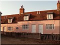
Almshouses in Queen Street at Coggeshall
A plaque on the building reads as follows:
Josiah Greenwood gave land at Butt Field (now Queen Street) on 2nd August 1795 to the Trustees of the market houses. The sale of the market houses by the said Trustees resulted in the sum of £50 being released. This money was used to build the first two almshouses in 1795 on the ground given by Josiah Greenwood. The almshouses were restored by the Trustees in 1981.
Image: © Robert Edwards
Taken: 21 Dec 2007
0.05 miles
2
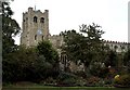
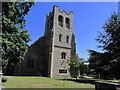
St. Peter-ad-Vincula church, Coggeshall, Essex
This large church was built during the 15th century but the tower we see today is a rebuild after the original was bombed during the Second World War. The nave was also damaged by bombing.
Image: © Robert Edwards
Taken: 3 Oct 2005
0.06 miles
3
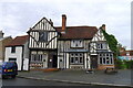
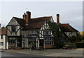
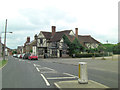
The Woolpack, Church Street, Coggeshall
The plaque by the door reads:
"Woolpack Inn, 14th-16th C, 1665 home of the Rev T Lowrey elected minister of the Church of England, Licensed for worship 1672, Licensed as an inn 1708"
Image: © Tim Heaton
Taken: 14 Oct 2020
0.08 miles
4
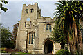
St Peter ad Vincula Church, Coggeshall
A church has existed on this site since Saxon times but like many old English churches the church we see today is an amalgamation of various building styles.
Image: © Neil Theasby
Taken: 7 Apr 2015
0.08 miles
5
St Peter ad Vincula Church, Coggeshall
This church was heavily damaged during World War II and a bomb destroyed much of the tower. The building has been tastefully restored.
Image: © Colin Park
Taken: 4 Jul 2015
0.08 miles
6
St. Peter ad Vincula Church Tower, Coggeshall
A fine 15th Century Church built on the back of the medieval wool trade that brought much wealth to the region.
Tastefully restored after bomb damage during the Second World War.
One of the many churches passed by on the Essex Way long distance footpath.
Image: © Chris Heaton
Taken: 14 Oct 2020
0.08 miles
7
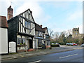
The Woolpack, Coggeshall
Timber framed inn and restaurant on Church Street, passed by on the Essex Way long distance footpath.
Grade II Listed Building.
Image: © Chris Heaton
Taken: 14 Oct 2020
0.08 miles
8
The Woolpack, Coggeshall
A grade II*(star) listed building, 15th century with later alterations.
Image: © Robin Webster
Taken: 15 Feb 2015
0.08 miles
9
The Woolpack
Originally a 15th C. dwelling it was altered in the 16th & 20th C. and is now Grade II listed with English Heritage Building ID: 116082. See also: http://www.britishlistedbuildings.co.uk/en-116082-the-woolpack-inn-coggeshall-essex
Image: © Stuart Logan
Taken: 23 Jun 2013
0.08 miles
10
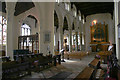
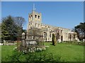
St Peter-ad-Vincula, Coggeshall
Interior looking south-west.
Image: © David Kemp
Taken: 12 Oct 2017
0.09 miles