IMAGES TAKEN NEAR TO
Rye Mill Lane, COLCHESTER, CO5 9SB
Introduction
This page details the photographs taken nearby to Rye Mill Lane, CO5 9SB by members of the Geograph project.
The Geograph project started in 2005 with the aim of publishing, organising and preserving representative images for every square kilometre of Great Britain, Ireland and the Isle of Man.

There are currently over 7.5m images from over14,400 individuals and you can help contribute to the project by visiting https://www.geograph.org.uk
Image Map
Images are licensed for reuse under creativecommons.org/licenses/by-sa/2.0
Notes
- Clicking on the map will re-center to the selected point.
- The higher the marker number, the further away the image location is from the centre of the postcode.
Image Listing (12 Images Found)
Images are licensed for reuse under creativecommons.org/licenses/by-sa/2.0
Image
Details
Distance
1
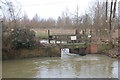
Weir on the Blackwater
The water overflows under the footbridge to follow the main river. to the left is the cut to provide water power for the former Rye Mill.
Image: © Trevor Harris
Taken: 16 Feb 2013
0.03 miles
2
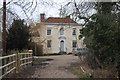
Rye Mill House
An impressive house on the opposite side of the Blackwater to Rye Mill.
Image: © Trevor Harris
Taken: 16 Feb 2013
0.03 miles
4
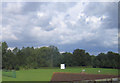
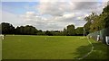
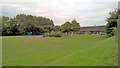
Feering cricket ground
Home of Kelvedon and Feering CC http://www.kfcc.club/
Image: © Stephen Craven
Taken: 28 Aug 2006
0.05 miles
5
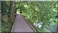
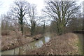
Board walk beside River Blackwater, Feering, Essex
Image: © Chris Morgan
Taken: 28 Aug 2018
0.07 miles
6
Along the boundary at Kelvedon & Feering Cricket Club
Image: © Chris Morgan
Taken: 28 Aug 2018
0.09 miles
8
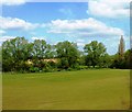
Field near Kelvedon & Feering Cricket Club
Footpath passes around edge of field. River Blackwater runs across image in mid-distance. Viewed from railway line.
Image: © Clint Mann
Taken: 4 May 2016
0.09 miles
9
Feering Church of England Voluntary Controlled Primary School
Image: © Chris Morgan
Taken: 28 Aug 2018
0.18 miles
10
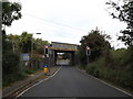
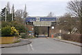
Coggeshall Road & Feering Road Railway Bridge
Bridge No.189 LTNl
Image: © Geographer
Taken: 10 Sep 2016
0.21 miles