IMAGES TAKEN NEAR TO
Layer Road, COLCHESTER, CO2 0HU
Introduction
This page details the photographs taken nearby to Layer Road, CO2 0HU by members of the Geograph project.
The Geograph project started in 2005 with the aim of publishing, organising and preserving representative images for every square kilometre of Great Britain, Ireland and the Isle of Man.

There are currently over 7.5m images from over14,400 individuals and you can help contribute to the project by visiting https://www.geograph.org.uk
Image Map
Images are licensed for reuse under creativecommons.org/licenses/by-sa/2.0
Notes
- Clicking on the map will re-center to the selected point.
- The higher the marker number, the further away the image location is from the centre of the postcode.
Image Listing (10 Images Found)
Images are licensed for reuse under creativecommons.org/licenses/by-sa/2.0
Image
Details
Distance
1
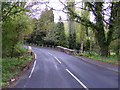
Kingsford Bridge carrying the B1026 toward Colchester
Image: © PAUL FARMER
Taken: 9 May 2010
0.05 miles
2
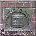
Old Boundary Marker
Bridge Marker on east bridge parapet of King's Ford Bridge, Roman River on the B1026. LAYER DE LA HAYE parish. ESSEX COUNTY COUNCIL / (coat of arms) / 1892 in raised lettering.
Milestone Society National ID: EX_LDLH01br
Image: © M Bardell
Taken: 29 Mar 2019
0.05 miles
3
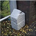
Old Boundary Marker
Parish Boundary Marker against northeast end of bridge parapet of King's Ford Bridge on B1026 Layer Road. On boundary of Colchester Borough and Layer de la Haye parish. Inscribed COLCHESTER / BOROUGH / BOUNDARY.
Milestone Society National ID: EX_COLDLH01pb
Image: © J V Nicholls
Taken: 17 Oct 2005
0.05 miles
4
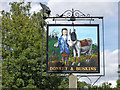
Inn sign, The Donkey and Buskins
For the pub, see Image
Image: © Robin Webster
Taken: 16 Jul 2016
0.08 miles
5
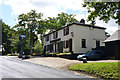
The Donkey and Buskins, Layer de la Haye
On the hill up from the Roman River.
Image: © Robin Webster
Taken: 16 Jul 2016
0.08 miles
6
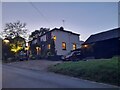
The Donkey and Buskins, Layer-de-la-Haye
Image: © David Howard
Taken: 27 Oct 2024
0.09 miles
7
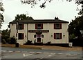
'The Donkey and Buskins' inn, Layer de la Haye, Essex
Image: © Robert Edwards
Taken: 26 Jun 2006
0.10 miles
8
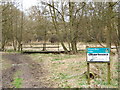
Roman River Reserve
This is the Roman River Valley Nature Reserve run by Essex Wildlife Trust http://www.essexwt.org.uk/. The reserve http://www.essexwt.org.uk/visitor_centres__nature_reserves/roman_river_nature_reserve/ is a valuable wetland habitat especially for insects and is one of the few places in Essex that is home to the Willow Tit. Continue on a virtual tour of Wildlife Trust Reserves in Essex by visiting
Image
Image: © Glyn Baker
Taken: 25 Mar 2006
0.18 miles
9
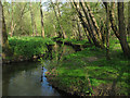
Roman River Valley Nature Reserve
The Roman River running through the woodland in the Roman River Valley Nature Reserve, managed by the Essex Wildlife Trust http://www.webcitation.org/6GRIiM1VU .
Image: © Roger Jones
Taken: 6 May 2013
0.22 miles
10
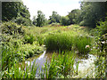
Small pond by footpath
The cleared area here is probably because of overhead power lines.
Image: © Robin Webster
Taken: 16 Jul 2016
0.22 miles