IMAGES TAKEN NEAR TO
New Cut, COLCHESTER, CO2 0EG
Introduction
This page details the photographs taken nearby to New Cut, CO2 0EG by members of the Geograph project.
The Geograph project started in 2005 with the aim of publishing, organising and preserving representative images for every square kilometre of Great Britain, Ireland and the Isle of Man.

There are currently over 7.5m images from over14,400 individuals and you can help contribute to the project by visiting https://www.geograph.org.uk
Image Map
Images are licensed for reuse under creativecommons.org/licenses/by-sa/2.0
Notes
- Clicking on the map will re-center to the selected point.
- The higher the marker number, the further away the image location is from the centre of the postcode.
Image Listing (16 Images Found)
Images are licensed for reuse under creativecommons.org/licenses/by-sa/2.0
Image
Details
Distance
1
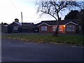
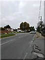
Bungalows on High Road, Layer-de-la-Haye
Image: © David Howard
Taken: 27 Oct 2024
0.13 miles
2
Layer de la Haye, village sign
See http://www.geograph.org.uk/photo/4173614 for detail
Image: © Bikeboy
Taken: 13 Sep 2014
0.19 miles
3
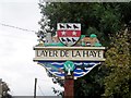
Layer de la Haye, village sign (detail)
See http://www.geograph.org.uk/photo/4173600 for a wider view. The building on the top right of the sign is the Old Forge Garage. See
Image: © Bikeboy
Taken: 13 Sep 2014
0.19 miles
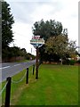
5
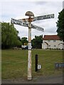
Direction Sign ? Signpost on the B1026 in Layer-de-la-Haye
Located on the northwest side of the crossroads of the B1026 Church Road/High Road, Malting Green Road and Birch Road in Layer-de-la-Haye parish. 4 arms and half-moon finial. See also http://www.flickr.com/photos/13171205@N08/8283891835.
Milestone Society National ID: EX_TL9620
Image: © John V Nicholls
Taken: Unknown
0.21 miles
6
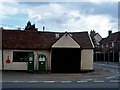
The Old Forge Garage, Layer de la Haye
Originally an C18 forge. Shown on the village sign. See http://www.geograph.org.uk/photo/4173614
Image: © Bikeboy
Taken: 13 Sep 2014
0.21 miles
7
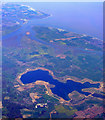
Layer de la Haye and Abberton Reservoir from the air
West Mersea on Mersea Island is to the right, Brightingsea is to the left, with the River Colne in between. Viewed from a Prague bound flight from Heathrow.
Image: © Thomas Nugent
Taken: 10 Apr 2011
0.21 miles
8
Layer de la Haye
The 1920's cast iron finger post was refurbished in 2013.
Image: © Bikeboy
Taken: 13 Sep 2014
0.21 miles
9
Junction of Church Road and Birch Road Layer de la Haye
Image: © PAUL FARMER
Taken: 23 Oct 2021
0.21 miles
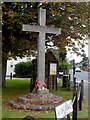
10
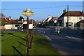
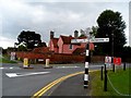
Village sign and crossroads, Layer de la Haye
The Layer Fox public house is on the right.
Image: © David Martin
Taken: 27 Mar 2017
0.21 miles