IMAGES TAKEN NEAR TO
Carnarvon Road, CLACTON-ON-SEA, CO15 6QE
Introduction
This page details the photographs taken nearby to Carnarvon Road, CO15 6QE by members of the Geograph project.
The Geograph project started in 2005 with the aim of publishing, organising and preserving representative images for every square kilometre of Great Britain, Ireland and the Isle of Man.

There are currently over 7.5m images from over14,400 individuals and you can help contribute to the project by visiting https://www.geograph.org.uk
Image Map
Images are licensed for reuse under creativecommons.org/licenses/by-sa/2.0
Notes
- Clicking on the map will re-center to the selected point.
- The higher the marker number, the further away the image location is from the centre of the postcode.
Image Listing (63 Images Found)
Images are licensed for reuse under creativecommons.org/licenses/by-sa/2.0
Image
Details
Distance
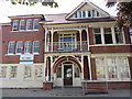
1
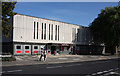
Clacton Library
The Station Road side of the building. It is located by the junction with Carnarvon Road, which passes it on the other side.
Image: © Martin Addison
Taken: 27 Aug 2009
0.04 miles
2
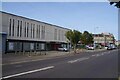
Clacton Library
The main entrance is around the corner in Station Rd. The shot is taken looking across Carnarvon Rd.
Image: © Glyn Baker
Taken: 30 Sep 2023
0.05 miles
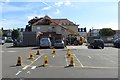
4
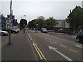
Westleigh House site - now extension of car park
The photo shows the site of Westleigh House, which formerly housed Tendring District Council offices. It was demolished in 2019, making way for extra spaces for the neighbouring car park.
Image] is from the same viewpoint in July 2014, only the tree, the white arrow on tarmac at bottom of picture and chimney pots of buildings in the High Street to the left being unchanged.
The picture was taken in Carnarvon Road. Beyond the car park, in the centre of the image, is the rear of the Sainsbury's store in the High Street. To the right, on the horizon, is the green dome of what was once a branch of Barclays Bank and is now a Sense shop, on the corner of the High Street and Station Road.
Image: © Duncan Graham
Taken: 6 Mar 2020
0.06 miles
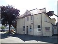
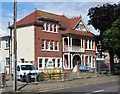
5
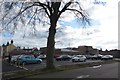
Westleigh House frontage - council offices now demolished
Shows the frontage of Westleigh House, Carnarvon Road, in 2014 five years before its demolition. The building was formerly office space for Tendring District Council. The site now provides additional spaces for the neighbouring car park.
Image: © Duncan Graham
Taken: 30 Jul 2014
0.06 miles
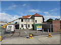
6
Rear of Westleigh House - council offices now demolished
Shows Westleigh House in Carnarvon Road, which formerly housed Tendring District Council offices, immediately before demolition in 2019 to make way for additional parking spaces.
The buff portable extension to the left of the red demolition skips was part of the existing office space and was also demolished, as were the former public toilets (the low brick building between tree and railings to right of picture).
Image: © Duncan Graham
Taken: 14 Jun 2019
0.06 miles
7
Side view of Westleigh House - council offices now demolished
Shows Westleigh House in Carnarvon Road, which formerly housed Tendring District Council offices, immediately before demolition in 2019 to make way for additional parking spaces.
The single-storey brick building to the right, a former public toilet, was also demolished.
Image: © Duncan Graham
Taken: 14 Jun 2019
0.06 miles
8
Side view of Westleigh House - council offices now demolished
Shows Westleigh House in Carnarvon Road, which formerly housed Tendring District Council offices, immediately before demolition in 2019 to make way for additional parking spaces.
Image: © Duncan Graham
Taken: 14 Jun 2019
0.06 miles
9

Westleigh House view across street - council offices now demolished
Shows Westleigh House in Carnarvon Road, which formerly housed Tendring District Council offices, immediately before demolition in 2019 to make way for additional parking spaces. The neighbouring car park is visible to the right.
Image: © Duncan Graham
Taken: 14 Jun 2019
0.06 miles
10
Westleigh House frontage - council offices now demolished
Shows Westleigh House in Carnarvon Road, which formerly housed Tendring District Council offices, immediately before demolition in 2019 to make way for additional parking spaces.
Image: © Duncan Graham
Taken: 14 Jun 2019
0.06 miles