IMAGES TAKEN NEAR TO
Fern Way, CLACTON-ON-SEA, CO15 2JB
Introduction
This page details the photographs taken nearby to Fern Way, CO15 2JB by members of the Geograph project.
The Geograph project started in 2005 with the aim of publishing, organising and preserving representative images for every square kilometre of Great Britain, Ireland and the Isle of Man.

There are currently over 7.5m images from over14,400 individuals and you can help contribute to the project by visiting https://www.geograph.org.uk
Image Map (Loading...)


Getting Data...Please wait
Leaflet Map data © OpenStreetMap
Images are licensed for reuse under creativecommons.org/licenses/by-sa/2.0
Notes
- Clicking on the map will re-center to the selected point.
- The higher the marker number, the further away the image location is from the centre of the postcode.
Image Listing (24 Images Found)
Images are licensed for reuse under creativecommons.org/licenses/by-sa/2.0
Image
Details
Distance
2
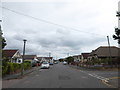
Jaywick: Meadow Way
This is the junction with Beach Crescent off to the left, showing the modern-day one-way system.
Image: © Nigel Cox
Taken: 28 Oct 2018
0.05 miles
3
Junction of Meadow Way and St Christopher's Way
Image: © Basher Eyre
Taken: 18 Jul 2020
0.05 miles
5
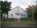
Jaywick: St Christopher's Church
St Christopher's Church is on Meadow Way and is part of the parish of St James in Clacton-on-Sea.
Frank Christopher Stedman bought a large tract of land at Jaywick in 1928 for a mixed beach and chalet development. St Christopher’s Church was completed in 1933 and dedicated by the Bishop of Chelmsford on 15 December that year. The name of St Christopher came from Mr Stedman who had donated the land for the church. Within the church there is a memorial to commemorate those who lost their lives during the flooding of Jaywick on the night of Saturday 31 January and the morning of Sunday 1 February 1953.
Image: © Nigel Cox
Taken: 28 Oct 2018
0.06 miles
7
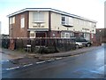
Jaywick: The Sheldrake
The Sheldrake in Meadow Way appears to be closed currently. During gales in January 2018 part of the roof was blown off.
Image: © Nigel Cox
Taken: 28 Oct 2018
0.07 miles
8
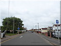
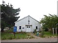
St Christopher's Way looking towards church, Jaywick Sands
The picture shows St Christopher's Way, a residential street in Jaywick Sands, looking towards St Christopher's Church (Anglican). The church is in the extreme south-east corner of grid square TM1413. St Christopher's Way car park is to the right of the photograph.
Image: © Duncan Graham
Taken: 22 Feb 2018
0.07 miles
9
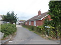
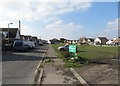
Fir Way, Jaywick Sands
A residential street. Photograph taken from sea wall. As can be seen, Jaywick is low-lying, making it prone to flooding.
Taken at a 180-degree angle from Image, a moment later.
Image: © Duncan Graham
Taken: 22 Feb 2018
0.13 miles
10
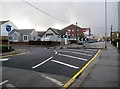
Broadway, Jaywick
Towards the rest of the world.
Image: © Robin Webster
Taken: 30 Nov 2018
0.13 miles