IMAGES TAKEN NEAR TO
Brian Bishop Close, WALTON ON THE NAZE, CO14 8QH
Introduction
This page details the photographs taken nearby to Brian Bishop Close, CO14 8QH by members of the Geograph project.
The Geograph project started in 2005 with the aim of publishing, organising and preserving representative images for every square kilometre of Great Britain, Ireland and the Isle of Man.

There are currently over 7.5m images from over14,400 individuals and you can help contribute to the project by visiting https://www.geograph.org.uk
Image Map (Loading...)


Getting Data...Please wait
Leaflet Map data © OpenStreetMap
Images are licensed for reuse under creativecommons.org/licenses/by-sa/2.0
Notes
- Clicking on the map will re-center to the selected point.
- The higher the marker number, the further away the image location is from the centre of the postcode.
Image Listing (9 Images Found)
Images are licensed for reuse under creativecommons.org/licenses/by-sa/2.0
Image
Details
Distance
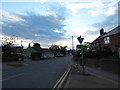
1
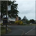
Bus stop sign at the end of Gouldings Avenue, Walton-on-the-Naze
Image: © David Smith
Taken: 16 Jun 2014
0.17 miles
2
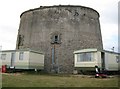
Walton-on-the-Naze: Martello Tower
Protection of the east coast of England from attack during the Napoleonic Wars was as important as that of the south coast as the government of the day were concerned in case an invasion was mounted to attack London through Essex and Suffolk. This is the Martello Tower at Walton-on-the-Naze, probably built around 1810, and located to guard over the numerous creeks north of Walton, rather than the sea.
The tower is not circular in plan but a curved structure with four main sides, about halfway between a circle and a square.
Although they were never put to the test the importance of these towers in the defence of the country after the threat during the Napoleonic War was over can be judged by the fact that they are not shown on the Ordnance Survey's 6" to the mile mapping editions of this area for 1880 and 1898, despite being of a scale large enough to be worth mapping. Only in 1925 do they suddenly appear, when presumably they were judged to be no longer of any military significance.
The land around the Walton-on-the-Naze tower is now used as a static residential and holiday home caravan park.
Image: © Nigel Cox
Taken: 30 Aug 2009
0.17 miles
3
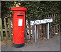
George VI postbox on Grove Avenue, Walton on the Naze
Postbox No. CO14 71.
Image: © JThomas
Taken: 26 Apr 2017
0.18 miles
4
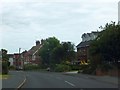
Houses in Kirby Road, Walton-on-the-Naze
Image: © David Smith
Taken: 16 Jun 2014
0.19 miles
5
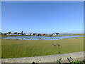
The Mere, Walton on the Naze
The Mere as it is now known was originally the 24 acre mill pond for the tide mill which stood on the red brick structure which now supports the grey shed in the middle of the scene. The two water wheels that drove the mill were housed in that structure beside which is what remains of sluice used to allow water on a rising tide to fill the pond and prevent its out-flow on the falling tide. From the time the mill ceased operations until the mid 1960/70's the mill pond was used as a boating lake where visitors to the town could try their hand at rowing, sailing or younger people spend hours in dinghies fitted with paddle wheels. Alas now all a distant memory, the area is planned for major development for a marina and housing.
Image: © Peter Pearson
Taken: 30 Sep 2015
0.21 miles
6
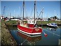
French trawler berthed in Walton Yacht Basin
The former trawler 'L'Aurore', registered at Camaret in Brittany, is berthed in the non-tidal basin which is managed by local yard Bedwells for the Walton Yacht Trust. http://www.wfyc.co.uk A depth of about two metres is maintained within the basin by means of a sill which is only opened for a short period before high water. At some neap tides there is insufficient depth outside to allow the gate to be opened.
Image: © Bob Jones
Taken: 19 Mar 2011
0.23 miles
8
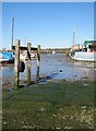
Scrubbing posts near Walton & Frinton Yacht Club
Yachts use these posts to moor against when their keels need a clean.
Image: © Bob Jones
Taken: 19 Mar 2011
0.25 miles
9
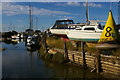
Yacht moorings at Walton-on-the-Naze
The sheltered creeks of Hamford Water provide a site for this marina situated "behind" Walton-on-the-Naze: the town as a whole faces the other way, towards the open sea.
Image: © Christopher Hilton
Taken: 5 Aug 2018
0.25 miles