IMAGES TAKEN NEAR TO
Summer Place, Hall Lane, WALTON ON THE NAZE, CO14 8HG
Introduction
This page details the photographs taken nearby to Summer Place, Hall Lane, CO14 8HG by members of the Geograph project.
The Geograph project started in 2005 with the aim of publishing, organising and preserving representative images for every square kilometre of Great Britain, Ireland and the Isle of Man.

There are currently over 7.5m images from over14,400 individuals and you can help contribute to the project by visiting https://www.geograph.org.uk
Image Map
Images are licensed for reuse under creativecommons.org/licenses/by-sa/2.0
Notes
- Clicking on the map will re-center to the selected point.
- The higher the marker number, the further away the image location is from the centre of the postcode.
Image Listing (41 Images Found)
Images are licensed for reuse under creativecommons.org/licenses/by-sa/2.0
Image
Details
Distance
1
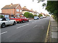
Walton-on-the-Naze: Percival Road
Infill housing construction between Hall Lane and the East Cliffs was a between-the-wars development. Percival Road is shown on the 1925 Ordnance Survey map but without any houses. However by the time that the 1938 edition was produced most were present.
Image: © Nigel Cox
Taken: 30 Aug 2009
0.04 miles
2
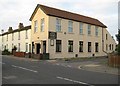
Walton-on-the-Naze: Walton Baptist Church
The Church is on Hall Lane at its junction with Beatrice Road. It appears on the Ordnance Survey map of 1925 as a Mission Hall. The cottages beyond might have originally been built for workers in Warner's iron foundry just up the road.
Image: © Nigel Cox
Taken: 30 Aug 2009
0.06 miles
3
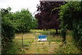
Barnes Spinney
Barnes Spinney was donated to Essex Wildlife Trust http://www.essexwt.org.uk/ by the late Mrs L Barnes. It was once a garden that covered about two acres. Visiting is normally only possible on special open days. You can take a look Image Continue a virtual tour of Wildlife Trust Reserves in Essex by visiting Image
Image: © Glyn Baker
Taken: 10 Aug 2009
0.08 miles
4
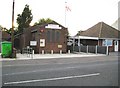
Walton-on-the-Naze: St George's Community Centre & Church Hall
I think that this building on Hall Lane is or was the Church of St George at the Naze. The stone tablet set into the wall reads:
To the Glory of God
This stone was laid by the
Rev H C Knocker MA
Vicar of this Parish 1903 - 1923
To whose untiring efforts
The erection of this
Building is largely due
December 1924
H C Knocker was Harold Cox Knocker (1870-1945), later Rector of Great Yeldham and Rector of Great Hallingbury.
Image: © Nigel Cox
Taken: 30 Aug 2009
0.08 miles
5
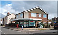
Naze Park Stores
On Hall Lane, Walton on the Naze.
Showing position of Postbox No. CO14 6.
See Image for postbox.
Image: © JThomas
Taken: 26 Apr 2017
0.08 miles
6
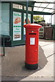
George VI postbox on Hall Lane, Walton on the Naze
Postbox No. CO14 6.
See Image] for context.
Image: © JThomas
Taken: 26 Apr 2017
0.08 miles
7
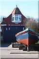
The Old Lifeboat House, Walton-on-the-Naze
The former lifeboat house, built in the latter part of the 19th century, is now the Walton Maritime Museum which houses an eclectic mix of maritime, urban, geological and seaside exhibits.
Image: © Bob Jones
Taken: 19 Mar 2011
0.10 miles
8
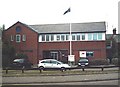
Coastguard Station, Walton
Next door to the Maritime Museum.
Image: © John Myers
Taken: 9 Aug 2007
0.10 miles
9

The Old Lifeboat House, East Terrace, Walton-on-Naze
The Old Lifeboat House now houses the Walton Maritime Museum.
Image: © PAUL FARMER
Taken: 31 Jan 2011
0.10 miles
10
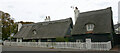
Thatched cottages in Hall Lane, Walton-on-the-Naze
These C18 cottages may well be the oldest buildings in the town.
Image: © David Kemp
Taken: 25 Sep 2022
0.11 miles