IMAGES TAKEN NEAR TO
Oakley Road, HARWICH, CO12 5DT
Introduction
This page details the photographs taken nearby to Oakley Road, CO12 5DT by members of the Geograph project.
The Geograph project started in 2005 with the aim of publishing, organising and preserving representative images for every square kilometre of Great Britain, Ireland and the Isle of Man.

There are currently over 7.5m images from over14,400 individuals and you can help contribute to the project by visiting https://www.geograph.org.uk
Image Map
Images are licensed for reuse under creativecommons.org/licenses/by-sa/2.0
Notes
- Clicking on the map will re-center to the selected point.
- The higher the marker number, the further away the image location is from the centre of the postcode.
Image Listing (9 Images Found)
Images are licensed for reuse under creativecommons.org/licenses/by-sa/2.0
Image
Details
Distance
1
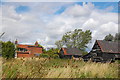
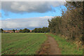
The Essex Way 163: Burnthouse Farm
The Essex Way leaves the road at Little Oakley by the farm here - Burnthouse Farm - which bizarrely enough has suffered a fire.
Image: © Trevor Harris
Taken: 7 Aug 2011
0.08 miles
2
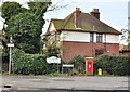
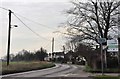
Mayes Lane post box
The junction of Mayes Lanes and Oakley Road, Ramsey, Essex.
Image: © MJ Reilly
Taken: 11 Mar 2009
0.09 miles
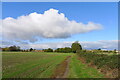
5
Essex Way heading North towards Little Oakley
The long distance footpath keeps to the high hedgerow
Image: © Chris Heaton
Taken: 17 Oct 2020
0.15 miles
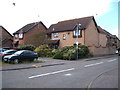
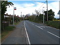
6
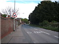
Oakley Road at the Memorial Ground
The B1414 heads out of town from the Mayes Lane junction..
Image: © MJ Reilly
Taken: 11 Mar 2009
0.15 miles
7
Oakley Road (B1414), Dovercourt
Looking north east.
Image: © JThomas
Taken: 26 Apr 2017
0.19 miles
8
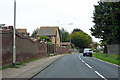
B1414 Oakley Road
Heading towards Dovercourt and Harwich.
Image: © Robin Webster
Taken: 8 Sep 2018
0.21 miles
9
Bus stop on Harwich Road (B1414)
Looking north.
Image: © JThomas
Taken: 26 Apr 2017
0.22 miles