IMAGES TAKEN NEAR TO
Station Road, MANNINGTREE, CO11 2LH
Introduction
This page details the photographs taken nearby to Station Road, CO11 2LH by members of the Geograph project.
The Geograph project started in 2005 with the aim of publishing, organising and preserving representative images for every square kilometre of Great Britain, Ireland and the Isle of Man.

There are currently over 7.5m images from over14,400 individuals and you can help contribute to the project by visiting https://www.geograph.org.uk
Image Map
Images are licensed for reuse under creativecommons.org/licenses/by-sa/2.0
Notes
- Clicking on the map will re-center to the selected point.
- The higher the marker number, the further away the image location is from the centre of the postcode.
Image Listing (185 Images Found)
Images are licensed for reuse under creativecommons.org/licenses/by-sa/2.0
Image
Details
Distance
3
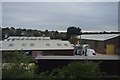
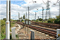
Manningtree Junction
Here the railway line splits. The line on the right goes to Harwich port the line on the left continues north east to Norwich.
Image: © Oxyman
Taken: 27 Aug 2007
0.06 miles
4
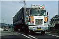
Big Mack
Scan Spedition truck on the A137, crossing the London Norwich mainline at Manningtree before the line was electrified. The truck is en-route to Harwich docks where it will board a ferry to its Denmark base. The vehicle must have been a regular visitor as it carries both Danish and UK registrations (the latter may be that of the trailer). Along with the Danish Flag, the truck carries its TIR badge indicating that it is a sealed vehicle and that minimal customs checks will be required - thus speeding its journey. See Wikipedia for further info on TIR.
Image: © Martin Addison
Taken: Unknown
0.06 miles
5
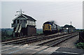
Manningtree South Junction
The driver of crosseyed 37052 cracks on the power - clearly not stopping at Manningtree! Taken before the electrification of the Ipswich and Norwich line, this Junction forms the western end of a triangle giving access to the Harwich Docks Branch, the tracks for which diverge to the right. The yellow speed limit sign advises drivers that the maximum speed around the curve to Harwich is 25mph. Behind is a platelayers hut with some permanent way maintenance equipment outside. The Signal box had been converted some years before from semaphore to colour light signalling. The signal box was removed when the line was electrified and the platelayers hut was replaced by power supply equipment. Compare with the current scene in Oxyman's photo from the same spot - Image
Image: © Martin Addison
Taken: Unknown
0.07 miles

9
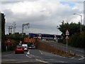
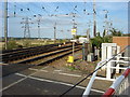
Bridge and level crossing near Manningtree Station
The Great Eastern Main Line crosses the A137 Colchester-Ipswich road. The bridge is too low and narrow for some vehicles. They use the level crossing.
Image: © Bikeboy
Taken: 13 Sep 2014
0.08 miles
10
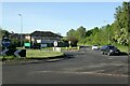
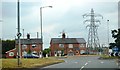
Roundabout near Manningtree Station
The village sign on the far side of the roundabout, in front of the left hand house, is in fact for Lawford rather than Manningtree.
Image: © Alan Murray-Rust
Taken: 12 May 2022
0.08 miles