IMAGES TAKEN NEAR TO
Harwich Road, MANNINGTREE, CO11 1LQ
Introduction
This page details the photographs taken nearby to Harwich Road, CO11 1LQ by members of the Geograph project.
The Geograph project started in 2005 with the aim of publishing, organising and preserving representative images for every square kilometre of Great Britain, Ireland and the Isle of Man.

There are currently over 7.5m images from over14,400 individuals and you can help contribute to the project by visiting https://www.geograph.org.uk
Image Map
Images are licensed for reuse under creativecommons.org/licenses/by-sa/2.0
Notes
- Clicking on the map will re-center to the selected point.
- The higher the marker number, the further away the image location is from the centre of the postcode.
Image Listing (74 Images Found)
Images are licensed for reuse under creativecommons.org/licenses/by-sa/2.0
Image
Details
Distance
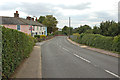
2

Allotments in New Mistley
A scrap of land between the B1352 and the railway.
Image: © Glyn Baker
Taken: 5 May 2023
0.03 miles
3
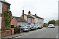
Cottages, Beckford Road, Mistley
The cottages continue round the corner onto Harwich Road.
Image: © Robin Webster
Taken: 30 Oct 2016
0.04 miles
4

Cottages, Harwich Road, Mistley
These continue round the far corner onto Beckford Road.
Image: © Robin Webster
Taken: 30 Oct 2016
0.04 miles
5
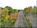
Railway east of Mistley station
Two disused turnouts with their crossings removed and point blades fixed in position are below. The one on the right was for a siding, which a long time ago was connected to a sharply curved and inclined line to Mistley Quay passing under the main line and turning through 180 degrees on its way down. This feature was just beyond the far bridge. This connection was removed, leaving only a siding. It was replaced by a zig-zag route, latterly leaving the main line by the turnout on the left. It is interesting that the speed restriction sign for this route is still in place, after years of disuse. A two lever ground frame for the right-hand turnout is on the right, but not connected, although point rodding trails off to somewhere, almost certainly to the catch point for the siding. There is probably something similar hidden in the bracken for the left-hand connection.
Image: © Robin Webster
Taken: 30 Oct 2016
0.05 miles
6

Chapel Cut, Mistley
The chapel is the building with a porch on the left.
Image: © Robin Webster
Taken: 30 Oct 2016
0.06 miles
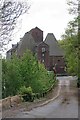
7

Anchor Inn, Mistley
The Anchor Inn at Mistley.
Image: © Malc McDonald
Taken: 18 Jul 2015
0.06 miles
8
The Wharf at New Mistley
Taken through the locked gates to the wharf
Image: © Glyn Baker
Taken: 5 May 2023
0.06 miles
9
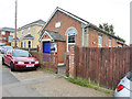
Mistley Methodist chapel
Tucked away down Chapel Cut, a bit of a glorified back alley.
Image: © Robin Webster
Taken: 30 Oct 2016
0.06 miles
10
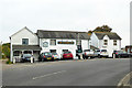
The Anchor Inn, Mistley
On the main road, Harwich Road.
Image: © Robin Webster
Taken: 30 Oct 2016
0.06 miles