IMAGES TAKEN NEAR TO
The Common, SUDBURY, CO10 9RL
Introduction
This page details the photographs taken nearby to The Common, CO10 9RL by members of the Geograph project.
The Geograph project started in 2005 with the aim of publishing, organising and preserving representative images for every square kilometre of Great Britain, Ireland and the Isle of Man.

There are currently over 7.5m images from over14,400 individuals and you can help contribute to the project by visiting https://www.geograph.org.uk
Image Map
Images are licensed for reuse under creativecommons.org/licenses/by-sa/2.0
Notes
- Clicking on the map will re-center to the selected point.
- The higher the marker number, the further away the image location is from the centre of the postcode.
Image Listing (480 Images Found)
Images are licensed for reuse under creativecommons.org/licenses/by-sa/2.0
Image
Details
Distance
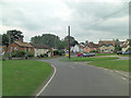
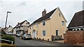
2
Salvation Army, Lavenham
Located on Lower Road, with houses beyond, near the junction with the main A1141 from Brent Eleigh.
Image: © Andrew Hill
Taken: 28 Nov 2009
0.04 miles
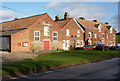
3
Lower end of Water Street, Lavenham
These are the first houses after the road from Brent Eleigh turns towards the centre of Lavenham. There are many historic buildings further up the street off the left of the picture.
Image: © Andrew Hill
Taken: 28 Nov 2009
0.04 miles
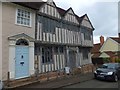
4
![Lavenham houses [63]](https://s3.geograph.org.uk/geophotos/06/75/02/6750215_369676d2_120x120.jpg)
Lavenham houses [63]
Number 39 Water Street is a 16th century timber framed and plastered house. Listed, grade II, with details at: https://historicengland.org.uk/listing/the-list/list-entry/1181354
Lavenham is a village in Suffolk about 5 miles north east of Sudbury. The village has Saxon origins but is best known as a medieval wool town. Granted a market charter in 1257, the village prospered in the 15th century and many buildings date to that period. The town grew so fast that many of the houses were built in haste with green timber. As the wood dried, the timbers warped causing the houses to bend at unexpected angles. Unfortunately, the good times didn't last long and the cloth industry declined so no one had money to rebuild their homes and Lavenham’s crooked houses were left as they were.
Image: © Michael Dibb
Taken: 13 Sep 2020
0.05 miles
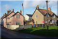
5
Shilling Old Grange, Lavenham
The building was reconstructed in the 1920s
Image: © David Smith
Taken: 19 Jun 2014
0.05 miles
6
![Lavenham houses [83]](https://s1.geograph.org.uk/geophotos/06/75/12/6751213_9584b95c_120x120.jpg)
Lavenham houses [83]
Number 18 Shilling Street is a small timber framed and plastered house believed to be 15th century. Listed, grade II, with details at: https://historicengland.org.uk/listing/the-list/list-entry/1181289
Lavenham is a village in Suffolk about 5 miles north east of Sudbury. The village has Saxon origins but is best known as a medieval wool town. Granted a market charter in 1257, the village prospered in the 15th century and many buildings date to that period. The town grew so fast that many of the houses were built in haste with green timber. As the wood dried, the timbers warped causing the houses to bend at unexpected angles. Unfortunately, the good times didn't last long and the cloth industry declined so no one had money to rebuild their homes and Lavenham’s crooked houses were left as they were.
Image: © Michael Dibb
Taken: 13 Sep 2020
0.05 miles
7

18 Shilling Street, Lavenham
https://historicengland.org.uk/listing/the-list/list-entry/1181289?section=official-list-entry
Image: © Sandy Gerrard
Taken: 22 Apr 2023
0.05 miles
8
![Lavenham houses [82]](https://s2.geograph.org.uk/geophotos/06/75/12/6751206_815c5b40_120x120.jpg)
Lavenham houses [82]
Arundel House, number 17 Shilling Street is 16th or 17th century greatly altered in the 18th century and later. Timber framed and plastered with a Tuscan doorcase. There is a rear wing. Listed, grade II, with details at: https://historicengland.org.uk/listing/the-list/list-entry/1037163
Lavenham is a village in Suffolk about 5 miles north east of Sudbury. The village has Saxon origins but is best known as a medieval wool town. Granted a market charter in 1257, the village prospered in the 15th century and many buildings date to that period. The town grew so fast that many of the houses were built in haste with green timber. As the wood dried, the timbers warped causing the houses to bend at unexpected angles. Unfortunately, the good times didn't last long and the cloth industry declined so no one had money to rebuild their homes and Lavenham’s crooked houses were left as they were.
Image: © Michael Dibb
Taken: 13 Sep 2020
0.06 miles
9
Arundel House, Lavenham
https://historicengland.org.uk/listing/the-list/list-entry/1037163?section=official-list-entry
Image: © Sandy Gerrard
Taken: 22 Apr 2023
0.06 miles
10
![Lavenham houses [62]](https://s2.geograph.org.uk/geophotos/06/75/02/6750214_29be1d4f_120x120.jpg)
Lavenham houses [62]
Number 37 Water Street is gable end to the street and has its entrance door in Shilling Street. A late 18th or early 19th century building in brick. Listed, grade II, with details at: https://historicengland.org.uk/listing/the-list/list-entry/1037170
Lavenham is a village in Suffolk about 5 miles north east of Sudbury. The village has Saxon origins but is best known as a medieval wool town. Granted a market charter in 1257, the village prospered in the 15th century and many buildings date to that period. The town grew so fast that many of the houses were built in haste with green timber. As the wood dried, the timbers warped causing the houses to bend at unexpected angles. Unfortunately, the good times didn't last long and the cloth industry declined so no one had money to rebuild their homes and Lavenham’s crooked houses were left as they were.
Image: © Michael Dibb
Taken: 13 Sep 2020
0.06 miles