IMAGES TAKEN NEAR TO
Prentice Hall Lane, MALDON, CM9 8RW
Introduction
This page details the photographs taken nearby to Prentice Hall Lane, CM9 8RW by members of the Geograph project.
The Geograph project started in 2005 with the aim of publishing, organising and preserving representative images for every square kilometre of Great Britain, Ireland and the Isle of Man.

There are currently over 7.5m images from over14,400 individuals and you can help contribute to the project by visiting https://www.geograph.org.uk
Image Map
Images are licensed for reuse under creativecommons.org/licenses/by-sa/2.0
Notes
- Clicking on the map will re-center to the selected point.
- The higher the marker number, the further away the image location is from the centre of the postcode.
Image Listing (6 Images Found)
Images are licensed for reuse under creativecommons.org/licenses/by-sa/2.0
Image
Details
Distance
1
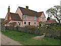
Rolls Farmhouse, Tollesbury (listed building)
House. Mid-C16, timber framed, plastered with some exposed framing.
Listed building entry Number: 1120903 http://list.english-heritage.org.uk/resultsingle.aspx?uid=1120903
Image: © Roger Jones
Taken: 30 Mar 2014
0.00 miles
2
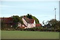
Rolls Farm
A 16th Century farmhouse with 21st century green energy.
Image: © Glyn Baker
Taken: 28 Oct 2016
0.01 miles
3
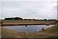
Triangular Pond Near Rolls Farm
Looking towards Image
Image: © Glyn Baker
Taken: 28 Oct 2016
0.01 miles
4
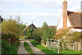
Track passing Rolls Farm
The track heads inland past Rolls Farm towards Prentice Hall Farm (and indeed becomes Prentice Hall Lane).
Image: © Trevor Harris
Taken: 27 Sep 2013
0.04 miles
5
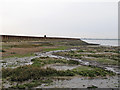
Mudflats & seawall, Tollesbury
Taken from the intertidal zone looking towards the seawall on the shore of the Blackwater Estuary.
A public footpath runs along the seawall, note the walker in the distance.
Image: © Roger Jones
Taken: 30 Mar 2014
0.13 miles
6

Seawall near Rolls Farm
Seawall, borrow dyke, and the Blackwater estuary looking towards Maldon.
Image: © Trevor Harris
Taken: 27 Sep 2013
0.21 miles