IMAGES TAKEN NEAR TO
Spar-Hawks, Rectory Road, MALDON, CM9 6PX
Introduction
This page details the photographs taken nearby to Spar-Hawks, Rectory Road, CM9 6PX by members of the Geograph project.
The Geograph project started in 2005 with the aim of publishing, organising and preserving representative images for every square kilometre of Great Britain, Ireland and the Isle of Man.

There are currently over 7.5m images from over14,400 individuals and you can help contribute to the project by visiting https://www.geograph.org.uk
Image Map
Images are licensed for reuse under creativecommons.org/licenses/by-sa/2.0
Notes
- Clicking on the map will re-center to the selected point.
- The higher the marker number, the further away the image location is from the centre of the postcode.
Image Listing (14 Images Found)
Images are licensed for reuse under creativecommons.org/licenses/by-sa/2.0
Image
Details
Distance
1
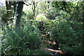
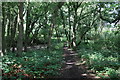
Stream and Footbridges
Two footbridges carry footpaths over the stream in The Wilderness. The handrails of the upstream bridge are just visible behind the ivy covered tree trunk.
Image: © Paul Franks
Taken: 17 Aug 2018
0.13 miles
2
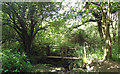
Footbridge on footpath, woodland, Woodham Walter
This is on a footpath that leads south from Blue Mill Lane. From here you can choose alternate routes to Woodham Walter village centre (The Street) or "The Wilderness"
Image: © Roger Jones
Taken: 21 May 2011
0.13 miles
3
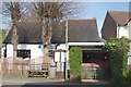
Memorial Shelter & Nursery
The bus shelter in Woodham Walter is a practical memorial to the men of the village who died in WWII, see Image The weatherboarded building is a nursery. The people of this village chose not to remember the fallen with a lump of stone but with memorials that enrich the lives of
the living see Image
Image: © Glyn Baker
Taken: 6 May 2016
0.14 miles
4
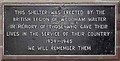
Shelter Dedication
This plaque is in the Woodham Mortimer Bus Shelter Image
Image: © Glyn Baker
Taken: 6 May 2016
0.14 miles
6
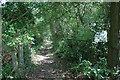
Footpath entering The Wilderness
As this is a public footpath the gates are presumably now redundant. The signpost on the right may once have given relevant information, but the writing on it has almost completely faded.
Image: © Paul Franks
Taken: 17 Aug 2018
0.14 miles
7
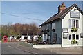
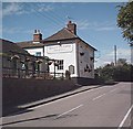
The Queen Vic
In the background you can see the former Post Office which is now a nursery and the bush shelter which is a practical war memorial to those who were killed in WWII. The people of Woodham Walter seem to have a bit of imagination where it comes to war memorials see Image
Image: © Glyn Baker
Taken: 6 May 2016
0.14 miles
8
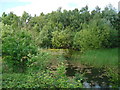
Disused Pit, nr Blue Mill Lane, Woodham Walter
Water and Nature seem to have successfully colonised this old pit, South of Blue Mill Lane, Woodham Walter
Image: © Roger Jones
Taken: 21 May 2011
0.16 miles
9
The Queen Victoria, Woodham Walter
One of three pubs in Woodham Walter.
Image: © John Myers
Taken: 1 Sep 2006
0.18 miles
10
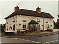
'The Queen Victoria' public house at Woodham Walter, Essex
Image: © Robert Edwards
Taken: 18 Oct 2006
0.18 miles