IMAGES TAKEN NEAR TO
Repertor Drive, MALDON, CM9 6FQ
Introduction
This page details the photographs taken nearby to Repertor Drive, CM9 6FQ by members of the Geograph project.
The Geograph project started in 2005 with the aim of publishing, organising and preserving representative images for every square kilometre of Great Britain, Ireland and the Isle of Man.

There are currently over 7.5m images from over14,400 individuals and you can help contribute to the project by visiting https://www.geograph.org.uk
Image Map
Images are licensed for reuse under creativecommons.org/licenses/by-sa/2.0
Notes
- Clicking on the map will re-center to the selected point.
- The higher the marker number, the further away the image location is from the centre of the postcode.
Image Listing (7 Images Found)
Images are licensed for reuse under creativecommons.org/licenses/by-sa/2.0
Image
Details
Distance
1
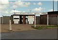
The entrance to Maldon Town Football Club
The club was established in 1946 and they have been using this ground in Park Drive since 1994.
Image: © Robert Edwards
Taken: 29 Apr 2008
0.12 miles
2
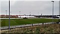
Wallace Binder Ground
Home stadium of Maldon and Tiptree FC.
Image: © Stuart Shepherd
Taken: 24 Mar 2018
0.12 miles
3
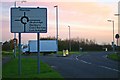
Mundon Rd Maldon
This roundabout is on Mundon Rd Maldon where it is intersected by Limebrook Rd and Park Drive
Image: © Glyn Baker
Taken: 2 Dec 2006
0.18 miles


6
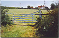
South House Farm, Maldon.
Behind the farm is the site of the Battle of Maldon (991) as marked on OS maps. The battle was probably fought over these fields and up to the hill on which Maldon town is built. The battle was a victory for Viking invaders over the British - Danish soldiers. Behind the farm too is the causeway to Northey Island where the Vikings camped (access permission needed).
Image: © Colin Smith
Taken: 8 Jun 2006
0.22 miles
7
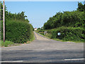
Track to Northey Island, Maldon
This private road, seen at the junction of Mundon Road, Maldon, is also a public footpath which leads to South House Farm, past the site of the battle of the Battle of Maldon (991), and on to Northey Island which is now a National Trust site.
Image: © Roger Jones
Taken: 6 Jul 2013
0.23 miles