IMAGES TAKEN NEAR TO
Steeple Road, CHELMSFORD, CM3 6BE
Introduction
This page details the photographs taken nearby to Steeple Road, CM3 6BE by members of the Geograph project.
The Geograph project started in 2005 with the aim of publishing, organising and preserving representative images for every square kilometre of Great Britain, Ireland and the Isle of Man.

There are currently over 7.5m images from over14,400 individuals and you can help contribute to the project by visiting https://www.geograph.org.uk
Image Map (Loading...)


Getting Data...Please wait
Leaflet Map data © OpenStreetMap
Images are licensed for reuse under creativecommons.org/licenses/by-sa/2.0
Notes
- Clicking on the map will re-center to the selected point.
- The higher the marker number, the further away the image location is from the centre of the postcode.
Image Listing (6 Images Found)
Images are licensed for reuse under creativecommons.org/licenses/by-sa/2.0
Image
Details
Distance
1
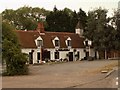
'The Mayland Mill', Mayland, Essex
This was once a well known inn in this area but it has now become an Indian Restaurant.
Image: © Robert Edwards
Taken: 13 Jul 2006
0.05 miles
2
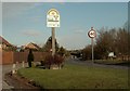
Mayland's village sign
The road is Steeple Road.
Image: © Robert Edwards
Taken: 7 Apr 2008
0.06 miles
3
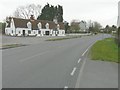
Mayland Mill, Steeple Road
This building is grade II listed and dates from the 18th century. It began life as a row of cottages before becoming a public house and then a restaurant
http://www.britishlistedbuildings.co.uk/en-117400-the-mayland-mill-public-house-mayland-es
Image: © John Baker
Taken: 31 Mar 2014
0.11 miles
4
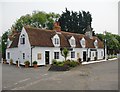
Zara Indian Restaurant, the Mayland Mill
Perhaps an unexpected use for a listed building in a rural situation. The building certainly appears extremely smartly kept.
According to the listing, the building started off as a row of cottages before becoming a pub. http://www.britishlistedbuildings.co.uk/en-117400-the-mayland-mill-public-house-mayland-es#.V12gTCghzo4 How the 'mill' name came about remains a puzzle.
If I'm right, then the building once stood much closer to the roadway. What seems to have happened is that the road has been re-aligned - a sharp bend being replaced by a curve of greater radius. Elsewhere, the ironing-out of a bend often means the old roadway is left to serve as a lay-by. Here, it provides an access road and parking space for the restaurant.
Image: © Stefan Czapski
Taken: 11 Jun 2016
0.11 miles
5
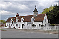
The Mayland Mill, Mayland
Now an Indian restaurant, earlier a pub and even earlier a row of cottages. A grade II listed building, dated 1756.
Image: © Robin Webster
Taken: 9 May 2021
0.11 miles
6
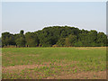
Arable field near Ashtree Farm, Mayland
Image: © Roger Jones
Taken: 13 Jul 2013
0.23 miles