IMAGES TAKEN NEAR TO
Lockside Marina, CHELMSFORD, CM2 6HY
Introduction
This page details the photographs taken nearby to Lockside Marina, CM2 6HY by members of the Geograph project.
The Geograph project started in 2005 with the aim of publishing, organising and preserving representative images for every square kilometre of Great Britain, Ireland and the Isle of Man.

There are currently over 7.5m images from over14,400 individuals and you can help contribute to the project by visiting https://www.geograph.org.uk
Image Map
Images are licensed for reuse under creativecommons.org/licenses/by-sa/2.0
Notes
- Clicking on the map will re-center to the selected point.
- The higher the marker number, the further away the image location is from the centre of the postcode.
Image Listing (56 Images Found)
Images are licensed for reuse under creativecommons.org/licenses/by-sa/2.0
Image
Details
Distance
1
Springfield Bridge
This bridge carries the footpath/cycle path over the Chelmer & Blackwater Navigation. Springfield Lock is just beyond the bridge.
Image: © terry joyce
Taken: 21 Jan 2011
0.01 miles
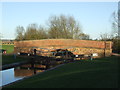
2
Springfield Lock & Basin
The interpretation board by the humpback bridge in the background declares that the lift bridge to the basin was designed by noted nineteenth century canal builder John Rennie. Looking at the materials making up the current bridge I have a feeling this is a case of Robert The Bruce’s Axe/Trigger’s Broom ….five new heads and four new handles!
Image: © Glyn Baker
Taken: 13 Apr 2017
0.01 miles
3
Springfield Bridge
This bridge carries the footpath/cycle path over The Chelmer & Blackwater Navigation; specifically Springfield Lock.
Image: © terry joyce
Taken: 21 Jan 2011
0.01 miles
4
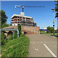
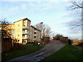
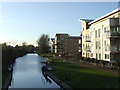
Chelmsford: building near Springfield Lock
This large block of flats has taken shape in the last year.
Image: © John Sutton
Taken: 15 May 2019
0.02 miles
5
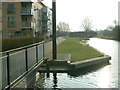
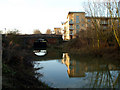
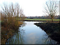
Springfield Basin and Springfield Lock
Springfield Basin looking towards Springfield Lock. The entrance to the private marina is to the left.
Image: © Robin Lucas
Taken: 13 Feb 2015
0.03 miles
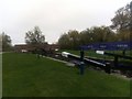
6
Canal bridge and lock gates, Chelmsford
The bridge carries a footpath and cycle route across a canal.
Image: © Malc McDonald
Taken: 20 Apr 2013
0.03 miles
7
Chelmer and Blackwater Navigation: Springfield Lock
Springfield Lock lifts the Chelmer and Blackwater Navigation out of the river into the top basin in Chelmsford.
Image: © Christopher Hilton
Taken: 15 Oct 2018
0.03 miles
8
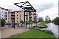
Chelmsford: Springfield Lock
The area around Springfield Basin is changing: flats on the right and further development going on behind the purple boarding on the left.
Image: © John Sutton
Taken: 22 Jun 2018
0.03 miles
9
Early evening, Chelmsford
Long shadows and early evening sunshine in Chelmsford.
Image: © Malc McDonald
Taken: 20 Apr 2013
0.03 miles
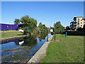
10
Chelmer & Blackwater Navigation
This is taken from the bridge by Springfield Lock looking towards the A138.
Image: © terry joyce
Taken: 21 Jan 2011
0.03 miles