1
Thorley Street coming into Bishop's Stortford
Image: © David Howard
Taken: 14 Apr 2019
0.10 miles
2
Train heading towards Bishop's Stortford
If running to time, this is probably the 13:28 stopping service from Liverpool Street to Cambridge. It is formed from unit 317 881.
Image: © Robin Webster
Taken: 25 Jun 2015
0.13 miles
3
Female Banded Demoiselle
Resting on vegetation near the River Stort, the female Calopteryx splendens differs particularly in wing colouration from the male, which has banded wings giving rise to the English name.
Image: © Robin Webster
Taken: 25 Jun 2015
0.15 miles
4
River Stort downstream of bridge 47
'Third Time Lucky' is moored.
Image: © Robin Webster
Taken: 25 Jun 2015
0.16 miles
5
The Coach and Horses pub, Spellbrook
See http://www.geograph.org.uk/photo/186041 for a view in 2006. The pub has had a new paint job since then.
Image: © Bikeboy
Taken: 9 Jun 2013
0.16 miles
6
Coach and Horses, Thorley Street
A grade II listed building, the blue plaque has 'Coach and Horses 1649'. The listing citation dates the oldest parts to late 15th or early 16th century, but that was before it was a pub and is described then as a 'hall-house'. See
Image for a detail and discussion of the unusual inn sign.
Image: © Robin Webster
Taken: 25 Jun 2015
0.20 miles
7
Down train near milepost 29
If running to time, this is probably the 13:25 from Liverpool Street to Stansted Airport. It is formed from two class 379 four car units, the rear one 379 015.
Image: © Robin Webster
Taken: 25 Jun 2015
0.20 miles
8
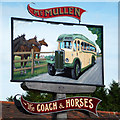
Inn sign, Coach and Horses
Plus points for the novel way of portraying this name, but many negative points for the depiction. Whilst JTB 749 is a real coach, a 1948 AEC Regal III with Burlingham body, it is unsurprisingly right-hand drive, not left, and would drive on the left-hand side of the road in this country. Clearly the artist worked from a reversed photograph, correcting the lettering (but not the 'Regal' on the radiator). It has been pointed out to me, something I did not notice at the time, that this is a cut-out sign, showing a correct view of the coach on the other side. A mirror image on this side is a consequence of using the same silhouette.
Image: © Robin Webster
Taken: 25 Jun 2015
0.21 miles
9
River Stort Navigation
Looking upstream, with a rather important tributary coming in under the towpath bridge. Important, as it forms the Hertfordshire - Essex border, which here deviates from the main river to include all of Pig Lane in Hertfordshire, which is across the bridge.
Image: © Robin Webster
Taken: 25 Jun 2015
0.21 miles
10
The Coach & Horses Pub
The blue plaque on the wall states a Coach & Horses pub has been on this site at Thorley Street since 1649.
Image: © Melvyn Cousins
Taken: 14 Jun 2006
0.21 miles


