IMAGES TAKEN NEAR TO
Riverside, BISHOP'S STORTFORD, CM23 3GP
Introduction
This page details the photographs taken nearby to Riverside, CM23 3GP by members of the Geograph project.
The Geograph project started in 2005 with the aim of publishing, organising and preserving representative images for every square kilometre of Great Britain, Ireland and the Isle of Man.

There are currently over 7.5m images from over14,400 individuals and you can help contribute to the project by visiting https://www.geograph.org.uk
Image Map
Images are licensed for reuse under creativecommons.org/licenses/by-sa/2.0
Notes
- Clicking on the map will re-center to the selected point.
- The higher the marker number, the further away the image location is from the centre of the postcode.
Image Listing (295 Images Found)
Images are licensed for reuse under creativecommons.org/licenses/by-sa/2.0
Image
Details
Distance
1
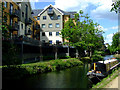
New flats by the River Stort
In the centre of Bishop's Stortford.
Image: © Thomas Nugent
Taken: 9 May 2011
0.01 miles
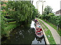
2
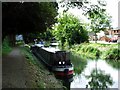
Narrowboats on the Stort
This is a reverse view of Image
Image: © Thomas Nugent
Taken: 3 Sep 2007
0.02 miles
3
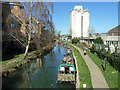
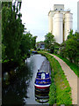
Stort Navigation above Station Road bridge
The next bridge up, just visible, is the limit of navigation. Allinson's flour mill is on the right.
Image: © Robin Webster
Taken: 16 Mar 2014
0.02 miles
4
New flats by the River Stort
In the centre of the town. The bridge at Station Road can be seen in the distance.
Image: © Thomas Nugent
Taken: 9 May 2011
0.02 miles
5
Narrowboats on the River Stort
Viewed from the bridge at Station Road.
Image: © Thomas Nugent
Taken: 29 Jul 2011
0.02 miles
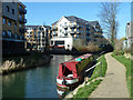
6
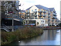
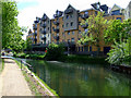
Riverside Apartments, Bishop's Stortford
These modern blocks overlook the turning basin on the Stort at the head of the river navigation.
http://www.bishopsstortfordtc.gov.uk/
Image: © Colin Smith
Taken: 12 Dec 2009
0.03 miles
7
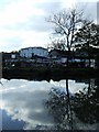
Building site by the Stort
In the centre of Bishop's Stortford.
Image: © Thomas Nugent
Taken: 19 Oct 2007
0.03 miles
8
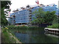
Building site by the Stort
Compare with this photo taken in October 2007 Image
Image: © Thomas Nugent
Taken: 19 Aug 2008
0.03 miles
9
Blue Crystal narrow boat on the River Stort, Cock Inn, Bishop's Stortford
View from the bridge on Station Road.
Image: © JThomas
Taken: 6 Jul 2019
0.03 miles
10
River Stort Navigation, Bishop's Stortford
The last chance to wind at the junction with the former continuation on the left to a terminal basin which is now built over. Navigation continues along the Hockerill Cut up to Hockerill Bridge (unnavigable) for somewhat more than 100 m around to the right.
Image: © Robin Webster
Taken: 16 Mar 2014
0.03 miles