IMAGES TAKEN NEAR TO
Hadham Road, BISHOP'S STORTFORD, CM23 1JH
Introduction
This page details the photographs taken nearby to Hadham Road, CM23 1JH by members of the Geograph project.
The Geograph project started in 2005 with the aim of publishing, organising and preserving representative images for every square kilometre of Great Britain, Ireland and the Isle of Man.

There are currently over 7.5m images from over14,400 individuals and you can help contribute to the project by visiting https://www.geograph.org.uk
Image Map (Loading...)


Getting Data...Please wait
Leaflet Map data © OpenStreetMap
Images are licensed for reuse under creativecommons.org/licenses/by-sa/2.0
Notes
- Clicking on the map will re-center to the selected point.
- The higher the marker number, the further away the image location is from the centre of the postcode.
Image Listing (3 Images Found)
Images are licensed for reuse under creativecommons.org/licenses/by-sa/2.0
Image
Details
Distance
1
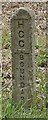
Old Boundary Marker by the A120, Hadham Road
Municipal Boundary Marker by the A120, in parish of Little Hadham (East Hertfordshire District), Hadham Road, verge, South side of road. There are several similar concrete posts along this stretch of the road.
Inscription reads vertically:-
HCC BOUNDARY
Surveyed
Milestone Society National ID: HE_LHAD01pb
Image: © Milestone Society
Taken: Unknown
0.17 miles
2
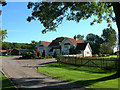
Hadham Lodge
Viewed from the private road which is also a bridleway
Image: © John Smith
Taken: 4 Oct 2006
0.19 miles
3
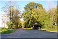
Bus shelter on Hadham Road
Set back on the corner of the drive to Hadham Park.
Image: © Robin Webster
Taken: 4 Nov 2014
0.20 miles