IMAGES TAKEN NEAR TO
Rowney Gardens, SAWBRIDGEWORTH, CM21 0AT
Introduction
This page details the photographs taken nearby to Rowney Gardens, CM21 0AT by members of the Geograph project.
The Geograph project started in 2005 with the aim of publishing, organising and preserving representative images for every square kilometre of Great Britain, Ireland and the Isle of Man.

There are currently over 7.5m images from over14,400 individuals and you can help contribute to the project by visiting https://www.geograph.org.uk
Image Map (Loading...)


Getting Data...Please wait
Leaflet Map data © OpenStreetMap
Images are licensed for reuse under creativecommons.org/licenses/by-sa/2.0
Notes
- Clicking on the map will re-center to the selected point.
- The higher the marker number, the further away the image location is from the centre of the postcode.
Image Listing (4 Images Found)
Images are licensed for reuse under creativecommons.org/licenses/by-sa/2.0
Image
Details
Distance
1
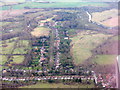
Pishiobury Drive
A private road leading to Pishiobury Park at Rowneybury. Leading southeast off the A1128 [Harlow Road], which runs across the lower part of the picture. The river is the Stort Navigation. https://en.wikipedia.org/wiki/Pishiobury , https://www.eastherts.gov.uk/article/35418/Pishiobury-Park .
Image: © M J Richardson
Taken: 6 Feb 2018
0.06 miles
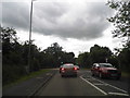
3

'Hand & Crown' inn, Sawbridgeworth, Herts.
Image: © Robert Edwards
Taken: 9 Aug 2006
0.20 miles
4
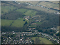
Rowneybury House from the air
Complete with a Lynx helicopter in the front garden. The house was once owned by David and Victoria Beckham.
Image: © Thomas Nugent
Taken: 16 Mar 2016
0.20 miles