IMAGES TAKEN NEAR TO
Humber Road, CHELMSFORD, CM1 7PG
Introduction
This page details the photographs taken nearby to Humber Road, CM1 7PG by members of the Geograph project.
The Geograph project started in 2005 with the aim of publishing, organising and preserving representative images for every square kilometre of Great Britain, Ireland and the Isle of Man.

There are currently over 7.5m images from over14,400 individuals and you can help contribute to the project by visiting https://www.geograph.org.uk
Image Map (Loading...)


Getting Data...Please wait
Leaflet Map data © OpenStreetMap
Images are licensed for reuse under creativecommons.org/licenses/by-sa/2.0
Notes
- Clicking on the map will re-center to the selected point.
- The higher the marker number, the further away the image location is from the centre of the postcode.
Image Listing (8 Images Found)
Images are licensed for reuse under creativecommons.org/licenses/by-sa/2.0
Image
Details
Distance
1
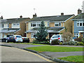
Houses on Humber Road
These were built with no forward extension and a separate garage to the right, which now has been absorbed into the house. The house to the left was extended first, then the central one (when I lived there). It has later been extended further.
Image: © Robin Webster
Taken: 11 Dec 2012
0.04 miles
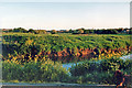
2
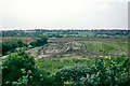
Earthworks for playing fields, 1983
The fields behind Humber Road sloping down to the River Chelmer are being levelled to convert them into playing fields. They were previously arable, and a little earlier held cattle. The hedge was preserved.
Image: © Robin Webster
Taken: Unknown
0.08 miles
3
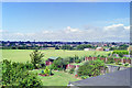
View over Chelmer Valley, 1988
Looking from one of the houses on Humber Road.
Image: © Robin Webster
Taken: Unknown
0.11 miles
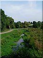
4
Springfield Hall Park
Recreation ground by the riverbank
Image: © John Myers
Taken: 6 May 2008
0.15 miles
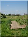
5
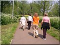
Riverside walk
A well surfaced path receives regular use from walkers alongside the River Chelmer.
Image: © William Metcalfe
Taken: 11 May 2006
0.18 miles
6
Site of future bridge, June 1985
Looking across the Chelmer where what is now the A1016 bridge was being set out. Note the pegs left and right. RHP works in the distance.
Image: © Robin Webster
Taken: Unknown
0.19 miles
7
Chelmer at Springfield
This is a picture of the river Chelmer, in Springfield Chelmsford where the A138 crosses it. The picture was taken looking downstream.
Image: © Glyn Baker
Taken: 3 Sep 2005
0.20 miles
8
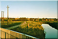
River Chelmer before the new road
An evening view looking from the fairly recent footbridge for the riverside walk to where the new road was to cross - just beyond the walkers. The white dot in the field on the right is a marking out peg, another is just visible on the river bank.
Image: © Robin Webster
Taken: Unknown
0.23 miles