IMAGES TAKEN NEAR TO
Kings Road, BRENTWOOD, CM14 4DJ
Introduction
This page details the photographs taken nearby to Kings Road, CM14 4DJ by members of the Geograph project.
The Geograph project started in 2005 with the aim of publishing, organising and preserving representative images for every square kilometre of Great Britain, Ireland and the Isle of Man.

There are currently over 7.5m images from over14,400 individuals and you can help contribute to the project by visiting https://www.geograph.org.uk
Image Map
Images are licensed for reuse under creativecommons.org/licenses/by-sa/2.0
Notes
- Clicking on the map will re-center to the selected point.
- The higher the marker number, the further away the image location is from the centre of the postcode.
Image Listing (71 Images Found)
Images are licensed for reuse under creativecommons.org/licenses/by-sa/2.0
Image
Details
Distance
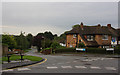
1
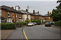
Westbury Road
Semi-detached houses near the junction with Kings Road.
Image: © Martin Addison
Taken: 9 Sep 2008
0.03 miles
2
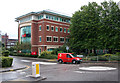
Chatham Way
A new cul-de-sac off Kings Road with office developments. The large building is the UK headquarters of Océ, a company supplying printers and similar items.
Image: © Martin Addison
Taken: 9 Sep 2008
0.04 miles
3
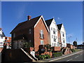
New housing development, Chatham Way off Kings Road, Brentwood
A new mixed development on the site of the old market.
Image: © John Winfield
Taken: 17 Sep 2005
0.06 miles
4
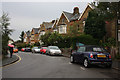
Westbury Road
Semi-detached housing. The road is popular with pedestrians and cars avoiding the junction of Kings Road and the High Street.
Image: © Martin Addison
Taken: 9 Sep 2008
0.06 miles
5
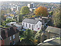
Crown Street Christian Fellowship, Brentwood
Image: © John Winfield
Taken: 3 Dec 2005
0.07 miles
7
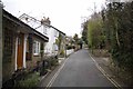
Primrose Hill Brentwood
A country lane in the middle of town! You can hardly hear the traffic for the twittering of birds.
Image: © Glyn Baker
Taken: 6 Mar 2013
0.09 miles
8
Downsland Drive
Looking down the hill from Westbury Road. Westbury Drive is out of shot on the right.
Image: © Martin Addison
Taken: 9 Sep 2008
0.09 miles
9
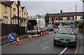
Surveying the Sewers
A sewer investigation unit checks out why water and other things are flowing up hill on Westbury Road. Beyond is the High Street with the obligatory queue of traffic waiting for the lights at the junction with Kings Road. Brentwood Tile Centre seems to be missing some tiles from its scrabble set.
Image: © Martin Addison
Taken: 9 Sep 2008
0.10 miles
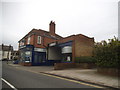
10
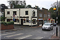
The Brewery Tap
Located on the corner of Kings Road and Primrose Hill, on the end of a small parade of shops.
Image: © Martin Addison
Taken: 9 Sep 2008
0.10 miles