IMAGES TAKEN NEAR TO
Laindon Common Road, BILLERICAY, CM12 9TD
Introduction
This page details the photographs taken nearby to Laindon Common Road, CM12 9TD by members of the Geograph project.
The Geograph project started in 2005 with the aim of publishing, organising and preserving representative images for every square kilometre of Great Britain, Ireland and the Isle of Man.

There are currently over 7.5m images from over14,400 individuals and you can help contribute to the project by visiting https://www.geograph.org.uk
Image Map
Images are licensed for reuse under creativecommons.org/licenses/by-sa/2.0
Notes
- Clicking on the map will re-center to the selected point.
- The higher the marker number, the further away the image location is from the centre of the postcode.
Image Listing (15 Images Found)
Images are licensed for reuse under creativecommons.org/licenses/by-sa/2.0
Image
Details
Distance
1
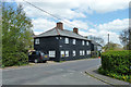
Wheatsheaf Cottage, Little Burstead
Named after the pub that was beyond. Formerly four cottages.
Image: © Robin Webster
Taken: 30 Apr 2013
0.07 miles
2
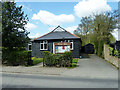
Little Burstead Village Hall
Black boarded, as are some houses to the right on Laindon Common Road.
Image: © Robin Webster
Taken: 30 Apr 2013
0.14 miles
3
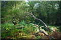
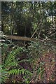
Laindon Common
As grazing ceased long ago much of Laindon Common has reverted to woodland
It is managed by “The Laindon Common Conservators” (they don’t appear to be webified yet). However there is some info at http://www.wildessex.net/sites/Laindon%20Common.htm
Image: © Glyn Baker
Taken: 17 Oct 2010
0.21 miles
5
Dried Up Crouch
Not a drop of water was evident in the River Crouch in Laindon Common http://www.wildessex.net/sites/Laindon%20Common.htm
Image: © Glyn Baker
Taken: 17 Oct 2010
0.22 miles
6
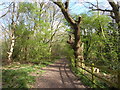
Path on Laindon Common
Laindon Common was set aside originally as grazing land. Now that grazing has ceased it has largely been colonised by trees, mainly oak and birch. It is irregular in shape and criss-crossed by footpaths. It is managed now by the Laindon Common Conservators, supported by Basildon Council and there is free access.
This is at the north-west corner on the approach from Burstead Golf Course.
Image: © Marathon
Taken: 2 Apr 2017
0.23 miles
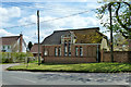
7
The former school at Little Burstead
This is towards the west of the village of Little Burstead. The building in the distance is the former school. The plaque on the near corner says 'LITTLE BURSTEAD SCHOOL 1891'.
Image: © Marathon
Taken: 2 Apr 2017
0.23 miles
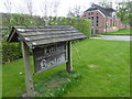
8
The Old School, Little Burstead
Dated 1891 on a foundation stone on the left corner. Now a church hall.
Image: © Robin Webster
Taken: 30 Apr 2013
0.23 miles
9
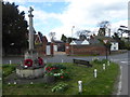
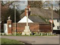
The war memorial at Little Burstead
The war memorial is on a small green towards the west of the village of Little Burstead. It is some way from the village church of St Mary's which is on its own, away to the south.
Image: © Marathon
Taken: 2 Apr 2017
0.24 miles
10
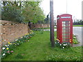
Scene in Little Burstead
This is towards the west of the village of Little Burstead near the former school.
Image: © Marathon
Taken: 2 Apr 2017
0.24 miles