IMAGES TAKEN NEAR TO
Gwysaney, MOLD, CH7 6PB
Introduction
This page details the photographs taken nearby to Gwysaney, CH7 6PB by members of the Geograph project.
The Geograph project started in 2005 with the aim of publishing, organising and preserving representative images for every square kilometre of Great Britain, Ireland and the Isle of Man.

There are currently over 7.5m images from over14,400 individuals and you can help contribute to the project by visiting https://www.geograph.org.uk
Image Map
Images are licensed for reuse under creativecommons.org/licenses/by-sa/2.0
Notes
- Clicking on the map will re-center to the selected point.
- The higher the marker number, the further away the image location is from the centre of the postcode.
Image Listing (18 Images Found)
Images are licensed for reuse under creativecommons.org/licenses/by-sa/2.0
Image
Details
Distance
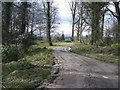
1
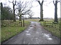
Cattle grid and track at Gwysaney
The stile on the right avoids the need to walk over the cattle grid.
Image: © John S Turner
Taken: 23 Mar 2008
0.04 miles
2
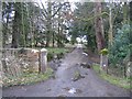
Private entrance to Gwysaney Hall
A side entrance to the hall from the track and public footpath on the west.
Image: © John S Turner
Taken: 23 Mar 2008
0.05 miles
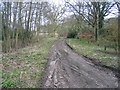
3
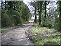
Track past Gwysaney Hall
This woodland track passes Gwysaney Hall.
Image: © John S Turner
Taken: 23 Mar 2008
0.07 miles
4
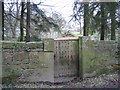
Old gate at Gwysaney
An interesting old studded gate in the stone wall at Gwysaney.
Image: © John S Turner
Taken: 23 Mar 2008
0.07 miles
5
Woodland track at Gwysaney
On the edge of the woodland the 'spire' of a shattered wind-blown tree is silhouetted against the sky. The Clwydian hills can be seen in the far distance.
Image: © John S Turner
Taken: 23 Mar 2008
0.08 miles
6
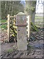
Gatepost and benchmark at Gwysaney
This gatepost is between the woodland and farmland at Gwysaney. See also Image
Image: © John S Turner
Taken: 23 Mar 2008
0.11 miles
7
Woodland track at Gwysaney
Some new trees have been planted along the edge of the track.
Image: © John S Turner
Taken: 23 Mar 2008
0.11 miles
8
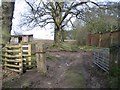
Gateway at Gwysaney
The track and footpath leave the woodland here and continue along the hollow way between the trees and the old garden wall. There is a benchmark on the left hand gatepost. See also Image
Image: © John S Turner
Taken: 23 Mar 2008
0.12 miles
9
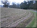
Farmland around Gwysaney
The crop here has been harvested and the land is lying fallow at the moment. The lane is also a public footpath providing several options for walks in the area.
Image: © John S Turner
Taken: 15 Jan 2007
0.13 miles
10
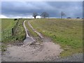
Farmland and track at Gwysaney
Threatening clouds hang over this farmland at Gwysaney.
Image: © John S Turner
Taken: 23 Mar 2008
0.15 miles