IMAGES TAKEN NEAR TO
Pont Y Mwynwr Road, MOLD, CH7 5LR
Introduction
This page details the photographs taken nearby to Pont Y Mwynwr Road, CH7 5LR by members of the Geograph project.
The Geograph project started in 2005 with the aim of publishing, organising and preserving representative images for every square kilometre of Great Britain, Ireland and the Isle of Man.

There are currently over 7.5m images from over14,400 individuals and you can help contribute to the project by visiting https://www.geograph.org.uk
Image Map
Images are licensed for reuse under creativecommons.org/licenses/by-sa/2.0
Notes
- Clicking on the map will re-center to the selected point.
- The higher the marker number, the further away the image location is from the centre of the postcode.
Image Listing (7 Images Found)
Images are licensed for reuse under creativecommons.org/licenses/by-sa/2.0
Image
Details
Distance
2
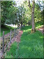
Clwydian Way south of Maeshafn
From Maeshafn, the Clwydian Way passes down a short drive, before coming along this fence. Probably a less well rambled part of the local area.
Image: © David Quinn
Taken: 30 May 2009
0.10 miles
3
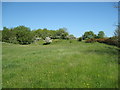
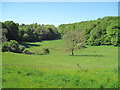
Farmland south of Maeshafn
An undulating and rocky field which I presume would be only used for sheep.
Image: © David Quinn
Taken: 30 May 2009
0.12 miles
4
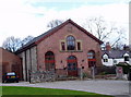
The Old Chapel, Maeshafn
This was the Calvinistic Methodist chapel at Maeshafn, built in 1820 and extended in 1843 and 1863. It has now been converted into a dwelling.
Image: © Eirian Evans
Taken: 17 Apr 2006
0.13 miles
5
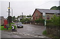
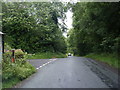
Maeshafn
The centre of the village of Maeshafn, between Llanferres and Mold
Image: © Eirian Evans
Taken: 22 May 2006
0.13 miles
6
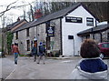
Miner's Arms, Maeshafn
Maeshafn used to be a mining village, with many lead mines in the area. There are also limestone quarries in the vicinity.
Image: © Eirian Evans
Taken: 17 Apr 2006
0.14 miles