IMAGES TAKEN NEAR TO
Tai Tudors, MOLD, CH7 5EB
Introduction
This page details the photographs taken nearby to Tai Tudors, CH7 5EB by members of the Geograph project.
The Geograph project started in 2005 with the aim of publishing, organising and preserving representative images for every square kilometre of Great Britain, Ireland and the Isle of Man.

There are currently over 7.5m images from over14,400 individuals and you can help contribute to the project by visiting https://www.geograph.org.uk
Image Map
Images are licensed for reuse under creativecommons.org/licenses/by-sa/2.0
Notes
- Clicking on the map will re-center to the selected point.
- The higher the marker number, the further away the image location is from the centre of the postcode.
Image Listing (8 Images Found)
Images are licensed for reuse under creativecommons.org/licenses/by-sa/2.0
Image
Details
Distance
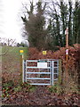
1
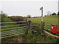
Public footpath, stile, gatepost and a bench mark at Bwlch y Ddeufryn, Gwernaffield
This footpath is at the Bwlch y Ddeufryn high point on the road between Gwernaffield and Pantymwyn. There is an Ordnance Survey bench mark at the bottom of the stone gatepost - Image
Image: © John S Turner
Taken: 4 Dec 2018
0.12 miles
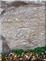
2
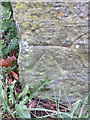
Bench mark at Bwlch y Dduefryn, Gwernaffield
This Ordnance Survey cut bench mark is on a gatepost next to a public footpath at Bwlch y Dduefryn - Image The bwlch is the high point of the road between Pantymwyn and Gwernaffield.
Image: © John S Turner
Taken: 4 Dec 2018
0.13 miles
3
Public footpath across Mold Golf Course
This public footpath crosses Mold Golf Course south from Cilcain Road, to an unclassified road - Image Beware flying golf balls!
Image: © John S Turner
Taken: 4 Dec 2018
0.15 miles
4
Bench mark in Pantymwyn, Flintshire
This Ordnance Survey bench mark is cut into the roadside face of a modernised old stone building on the corner of Cilcain Road and Pen y Fron Road - Image The mark was last recorded on the 1878 O.S. map.
Image: © John S Turner
Taken: 4 Dec 2018
0.16 miles
5
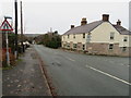
Cilcain Road and Pen y Fron Road junction, Pantymwyn
Looking across the junction of Pen y Fron Road and Cilcain Road in Pantymwyn. The restored building on the corner has an early Ordnance Survey cut bench mark on the Cilcain Road face - Image The bench mark was last recorded on the 1878 O.S. map.
Image: © John S Turner
Taken: 4 Dec 2018
0.17 miles
6
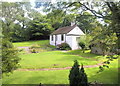
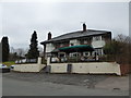
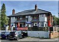
Bryn Teg
Head of Cae Rhug Lane ( once with its own lead mine)
Image: © Graham Burnett
Taken: 31 May 2005
0.18 miles