IMAGES TAKEN NEAR TO
Plas Lane, MOLD, CH7 4QL
Introduction
This page details the photographs taken nearby to Plas Lane, CH7 4QL by members of the Geograph project.
The Geograph project started in 2005 with the aim of publishing, organising and preserving representative images for every square kilometre of Great Britain, Ireland and the Isle of Man.

There are currently over 7.5m images from over14,400 individuals and you can help contribute to the project by visiting https://www.geograph.org.uk
Image Map
Images are licensed for reuse under creativecommons.org/licenses/by-sa/2.0
Notes
- Clicking on the map will re-center to the selected point.
- The higher the marker number, the further away the image location is from the centre of the postcode.
Image Listing (12 Images Found)
Images are licensed for reuse under creativecommons.org/licenses/by-sa/2.0
Image
Details
Distance
1
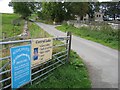
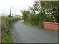
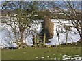
Lane to Gweryd Fishing Lakes
Access lane to Gweryd Fishing Lakes with Plâs Llanarmon in the trees on the right.
Image: © John S Turner
Taken: 28 Sep 2006
0.17 miles
2
Footpath to Llanarmon yn Ial
From opposite the lane to Gweryd Fishing Lakes this footpath crosses the snowy fields towards Llanarmon yn Ial.
Image: © John S Turner
Taken: 11 Feb 2007
0.17 miles
3
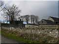
Plas, Llanarmon
Plas Llanarmon is a gentry house of the 17th century, later a farmhouse. In the late 19th century it was tenanted by John Parry (1835-95) whose campaign against collection of tithes from tenants led to his eviction (cf Parry Memorial at Capel Bethel, Rhiw Ial). The house is rubble stone, two storeys and attic with slate roofs.
Image: © Eirian Evans
Taken: 24 Feb 2011
0.18 miles
4
Pl?s Llanarmon
Moel y Plâs is behind the farm.
Image: © Eirian Evans
Taken: 19 Sep 2008
0.19 miles
5
Approaching Llanarmon yn I?l from the south
The B5431 curving round towards the village.
Image: © Eirian Evans
Taken: 9 Oct 2007
0.21 miles
6
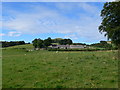
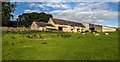
Plas Llanarmon
A Grade II listed farmhouse whose barns look like they need a little bit of repair.
Image: © Eirian Evans
Taken: 14 Jan 2019
0.21 miles
7
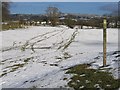
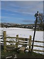
Footpath to Llanarmon yn Ial
Half way across the sheepfield there is a repeater footpath sign, which indicates the direction to the next stile. Without the lines in the snow, which roughly indicate the direction, the path would not be clear otherwise.
Image: © John S Turner
Taken: 11 Feb 2007
0.22 miles
8
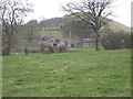
Footpath from Llanarmon yn Ial
Looking along the footpath across the sheepfield the prominent building is Plas Llanarmon. The rounded hill in the background is Moel y Plas.
Image: © John S Turner
Taken: 11 Feb 2007
0.22 miles
9
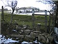
Footpath to Llanarmon yn Ial
Over the stile the footpath keeps to the right hand side of the hedge. Some of the houses of the village can just be seen through the large hawthorn.
Image: © John S Turner
Taken: 11 Feb 2007
0.22 miles
10
Plas-Llanarmon
Plas-Llanarmon farm.
Image: © Peter McDermott
Taken: 11 Sep 2016
0.23 miles