IMAGES TAKEN NEAR TO
Chester Road, MOLD, CH7 4HY
Introduction
This page details the photographs taken nearby to Chester Road, CH7 4HY by members of the Geograph project.
The Geograph project started in 2005 with the aim of publishing, organising and preserving representative images for every square kilometre of Great Britain, Ireland and the Isle of Man.

There are currently over 7.5m images from over14,400 individuals and you can help contribute to the project by visiting https://www.geograph.org.uk
Image Map
Images are licensed for reuse under creativecommons.org/licenses/by-sa/2.0
Notes
- Clicking on the map will re-center to the selected point.
- The higher the marker number, the further away the image location is from the centre of the postcode.
Image Listing (10 Images Found)
Images are licensed for reuse under creativecommons.org/licenses/by-sa/2.0
Image
Details
Distance
2
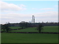
Farmland
Farmland seen from the junction of the A5104 and Padeswood Lake Road. In the distance is the chimney of the Padeswood cement factory, which dominates the landscape in this part of Flintshire.
Image: © Eirian Evans
Taken: 15 Feb 2008
0.05 miles
3
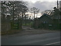
Lodge near Plas Newydd Farm
On the A5104.
Image: © Eirian Evans
Taken: 6 Jan 2007
0.06 miles
5

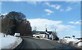
The former Camfa-Rhinallt Turnpike House
The former Camfa-Rhinallt Turnpike House stands at the junction of the A5104 and Padeswood Lake Road. There is an Ordnance Survey bench mark on the north east side of the house: Image
Image: © John S Turner
Taken: 4 Jul 2019
0.09 miles
6
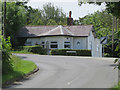
Former Camfa-Rhinallt Turnpike House
The former Camfa-Rhinallt Turnpike House stands at the junction of the A5104 and Padeswood Lake Road. Milestone Society National ID: FLT.NER
Image: © John S Turner
Taken: 4 Jul 2019
0.09 miles
7
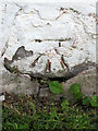
Bench mark on Camfa-Rhinallt Turnpike House
This Ordnance Survey bench mark is on the north east face of the former Camfa-Rhinallt Turnpike House at the junction of the A5104 and Padeswood Lake Road. See also Image
Image: © John S Turner
Taken: 4 Jul 2019
0.10 miles
8
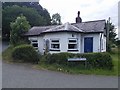
Former Camfa-Rhinallt Turnpike House by the A5104
Camfa-Rhinallt Toll House by the A5104, in parish of Nercwys (Flintshire District), Toll Bar Cottage, Chester Road junction with Padeswood Lake Road.
To be surveyed
Milestone Society National ID: FLT.NER
Image: © Milestone Society
Taken: Unknown
0.10 miles
9
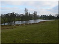
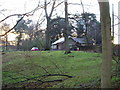
Lake near Plas Newydd Farm, Pontblyddyn
Image: © Eirian Evans
Taken: 15 Feb 2008
0.24 miles
10
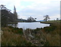
Lake near Plas Newydd Farm, Pontblyddyn
Image: © Eirian Evans
Taken: 15 Feb 2008
0.24 miles