IMAGES TAKEN NEAR TO
Pant Du Road, MOLD, CH7 4DD
Introduction
This page details the photographs taken nearby to Pant Du Road, CH7 4DD by members of the Geograph project.
The Geograph project started in 2005 with the aim of publishing, organising and preserving representative images for every square kilometre of Great Britain, Ireland and the Isle of Man.

There are currently over 7.5m images from over14,400 individuals and you can help contribute to the project by visiting https://www.geograph.org.uk
Image Map
Images are licensed for reuse under creativecommons.org/licenses/by-sa/2.0
Notes
- Clicking on the map will re-center to the selected point.
- The higher the marker number, the further away the image location is from the centre of the postcode.
Image Listing (5 Images Found)
Images are licensed for reuse under creativecommons.org/licenses/by-sa/2.0
Image
Details
Distance
1
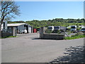
Lorry Park and Repair Centre
Presumably owned by or contracted to the quarry company.
Image: © David Quinn
Taken: 30 May 2009
0.16 miles
2
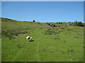
Clwydian Way Ascending Bryn Alyn
The path follows a track up to the top of Bryn Alyn.
Image: © David Quinn
Taken: 30 May 2009
0.21 miles
3
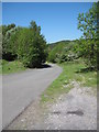
Byway/Access Road to Quarry
The byway continues from here to the junction at Four Crosses. At this end it is paved as a road for the trucks that go to the quarry.
Image: © David Quinn
Taken: 30 May 2009
0.22 miles
4
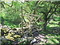
Steps on the Clwydian Way
The last field crossing before the Clwydian reaches the byway/access road near Bryn Alyn.
Image: © David Quinn
Taken: 30 May 2009
0.23 miles
5
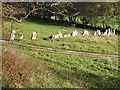
Stone Fence at Pant Du
This line of stones appears to have been set up as a fence rather than a wall. The area is indicated as Pant Du on the 25,000 O.S. map. - Pant is a 'hollow or depression', and Du is 'black', so 'Black Hollow' would seem to fit with the extensive lead mining that was carried out in these hills over many years. The photo is taken from the Clwydian Way.
Image: © John S Turner
Taken: 13 Nov 2006
0.24 miles