IMAGES TAKEN NEAR TO
Howgill Close, ELLESMERE PORT, CH66 4JH
Introduction
This page details the photographs taken nearby to Howgill Close, CH66 4JH by members of the Geograph project.
The Geograph project started in 2005 with the aim of publishing, organising and preserving representative images for every square kilometre of Great Britain, Ireland and the Isle of Man.

There are currently over 7.5m images from over14,400 individuals and you can help contribute to the project by visiting https://www.geograph.org.uk
Image Map
Images are licensed for reuse under creativecommons.org/licenses/by-sa/2.0
Notes
- Clicking on the map will re-center to the selected point.
- The higher the marker number, the further away the image location is from the centre of the postcode.
Image Listing (5 Images Found)
Images are licensed for reuse under creativecommons.org/licenses/by-sa/2.0
Image
Details
Distance
1
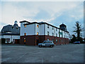
Quality Hotel, Little Sutton
1980's inside and out.
Image: © Jonathan Billinger
Taken: 2 Jan 2008
0.07 miles
2
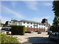
Quality Hotel, Little Sutton
Quality Hotel, on the Welsh Road (A550), Little Sutton.
Image: © Sue Adair
Taken: 3 Jun 2006
0.13 miles
3
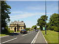
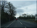
Welsh Road (A550) and Dehon House Lodge
Dehon House (run by the Sacred Heart Fathers for the Diocese of Shrewsbury) was a residential centre for youth work. It was closed in 2003.
Image: © Sue Adair
Taken: 3 Jun 2006
0.19 miles
4
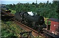
Drifting down to Hooton ? 1966
Ex LMS Hughes-Fowler 'Crab' 2-6-0 42765 at the head of a train of oil tankers from Stanlow refinery is about to pass a diesel multiple unit train on the Hooton to Helsby service.
This locomotive has survived into preservation and has been restored in LMS crimson lake livery, currently on the East Lancs Railway (2021) https://www.geograph.org.uk/photo/4148874
Image: © Alan Murray-Rust
Taken: 29 Sep 1966
0.22 miles