IMAGES TAKEN NEAR TO
North Wall Terminal, Merseyton Road, ELLESMERE PORT, CH65 2JF
Introduction
This page details the photographs taken nearby to North Wall Terminal, Merseyton Road, CH65 2JF by members of the Geograph project.
The Geograph project started in 2005 with the aim of publishing, organising and preserving representative images for every square kilometre of Great Britain, Ireland and the Isle of Man.

There are currently over 7.5m images from over14,400 individuals and you can help contribute to the project by visiting https://www.geograph.org.uk
Image Map
Images are licensed for reuse under creativecommons.org/licenses/by-sa/2.0
Notes
- Clicking on the map will re-center to the selected point.
- The higher the marker number, the further away the image location is from the centre of the postcode.
Image Listing (24 Images Found)
Images are licensed for reuse under creativecommons.org/licenses/by-sa/2.0
Image
Details
Distance
1
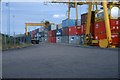
Containers at Ellesmere Port
Containers awaiting shipment or delivery to consignees. Cawoods Container Terminal, Ellesmere Port.
Image: © Tim Marshall
Taken: 28 Jul 1983
0.05 miles
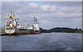
2
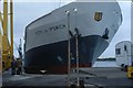
Vessel loading cargo for the Mediterranean
Vessel "City of Ipswich" (Ellerman City Liners), loads cargo for the Mediterranean at Cawoods Container Terminal, Ellesmere Port on 28/7/83
Image: © Tim Marshall
Taken: 28 Jul 1983
0.05 miles
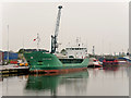
3
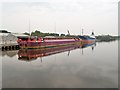
Manchester Ship Canal, Container Barge "Terra Marique" at Ellesmere Port
The Terra Marique is a specialist heavy lift towed barge designed to carry abnormal indivisible loads.
Image: © David Dixon
Taken: 11 May 2016
0.06 miles
4
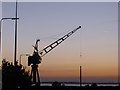
Small crane in Pre Dawn on the ship canal
This crane stands motionless in the pre dawn light by the side of the Manchester ship canal. In the background is the Mersey estuary.
Image: © Peter Shone
Taken: 3 Aug 2007
0.07 miles
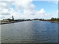
5
Ships at wharves at Ellesmere Port
On the Manchester Ship Canal; Mount Manisty is the mound in the distance.
Image: © Tom Pennington
Taken: 11 Sep 2014
0.08 miles
6
Ellesmere Port, Manchester Ship Canal
Passing a mineral depot on the left.
Image: © Mike Faherty
Taken: 18 Sep 2011
0.09 miles
7
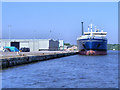
Ellesmere Port Wharf, Manchester Ship Canal
Oil/chemical tanker Furenås at Ellesmere Port.
Image: © David Dixon
Taken: 25 May 2012
0.10 miles
8
Container Ship Arklow Rogue Moored at Ellesmere Port
Image: © David Dixon
Taken: 11 May 2016
0.11 miles
10
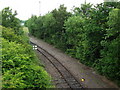
Manchester Ship Canal Railway seen from Merseyton Road bridge
This is part of the link between the privately owned dockside railways and the mainline. According to John Eyers website this section was double track until 1996. The now disconnected siding seen bearing right in the background led to Cawoods coal terminal. The line we see here bearing left was reopened in 2005 to Manisty Wharf to handle coal imported to feed Fiddlers Ferry power station.
Image: © John Brightley
Taken: 13 Jun 2010
0.13 miles