IMAGES TAKEN NEAR TO
Stour Court, ELLESMERE PORT, CH65 2HF
Introduction
This page details the photographs taken nearby to Stour Court, CH65 2HF by members of the Geograph project.
The Geograph project started in 2005 with the aim of publishing, organising and preserving representative images for every square kilometre of Great Britain, Ireland and the Isle of Man.

There are currently over 7.5m images from over14,400 individuals and you can help contribute to the project by visiting https://www.geograph.org.uk
Image Map (Loading...)


Getting Data...Please wait
Leaflet Map data © OpenStreetMap
Images are licensed for reuse under creativecommons.org/licenses/by-sa/2.0
Notes
- Clicking on the map will re-center to the selected point.
- The higher the marker number, the further away the image location is from the centre of the postcode.
Image Listing (6 Images Found)
Images are licensed for reuse under creativecommons.org/licenses/by-sa/2.0
Image
Details
Distance
3
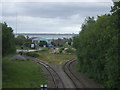
Manchester Ship Canal Railway
View from Merseyton Road bridge on the A5032.
Image: © JThomas
Taken: 15 Jun 2019
0.24 miles
4
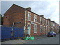
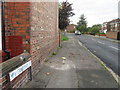
Terraced housing on Elm Street
Mostly taken over for business use.
Image: © JThomas
Taken: 15 Jun 2019
0.24 miles
6
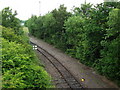
Manchester Ship Canal Railway seen from Merseyton Road bridge
This is part of the link between the privately owned dockside railways and the mainline. According to John Eyers website this section was double track until 1996. The now disconnected siding seen bearing right in the background led to Cawoods coal terminal. The line we see here bearing left was reopened in 2005 to Manisty Wharf to handle coal imported to feed Fiddlers Ferry power station.
Image: © John Brightley
Taken: 13 Jun 2010
0.24 miles